
Mapa topográfico Pasadena
Mapa interativo
Clique no mapa para exibir a altitude.
Sobre este mapa
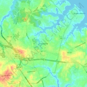
Nome: Mapa topográfico Pasadena, altitude, relevo.
Altitude média: 16 m
Altitude mínima: -2 m
Altitude máxima: 46 m
Pasadena is located at 39°6′46″N 76°33′7″W / 39.11278°N 76.55194°W / 39.11278; -76.55194 (39.112809, −76.551871) in northern Anne Arundel County. It is bordered to the north by the city of Baltimore, to the east by the tidal Patapsco River and by Riviera Beach, to the southeast by Lake Shore, to the south by Severna Park, and to the west by Glen Burnie. The original community of Pasadena, shown on USGS topographic maps at the intersection of Pasadena Road and Governor Ritchie Highway (Maryland Route 2), is now assigned by the U.S. Census Bureau to the Severna Park census-designated place, south of the border for the Pasadena CDP, which itself is centered along Mountain Road (Maryland Route 177) and includes the neighborhoods of Ashburn and Green Haven, and extends north along the Marley Neck peninsula all the way to the Baltimore city line.
Outros mapas topográficos
Clique em um mapa para visualizar sua topografia, sua altitude e seu relevo.
Annapolis
United States > Maryland > Anne Arundel County
Annapolis, Anne Arundel County, Maryland, United States
Altitude média: 8 m
Arnold
United States > Maryland > Anne Arundel County
Arnold, Anne Arundel County, Maryland, 21012, United States
Altitude média: 15 m
Monroe Gardens
United States > Maryland > Anne Arundel County > Glen Burnie
Monroe Gardens, Glen Burnie, Anne Arundel County, Maryland, 21061, United States
Altitude média: 22 m
Yorktown
United States > Maryland > Anne Arundel County > Glen Burnie
Yorktown, Glen Burnie, Anne Arundel County, Maryland, 21108, United States
Altitude média: 30 m
Bestgate Terrace
United States > Maryland > Anne Arundel County
Bestgate Terrace, Anne Arundel County, Maryland, 21405, United States
Altitude média: 22 m
Queen Anne Hill
United States > Maryland > Anne Arundel County
Queen Anne Hill, Anne Arundel County, Maryland, 20779, United States
Altitude média: 13 m
Crofton
United States > Maryland > Anne Arundel County
Crofton, Anne Arundel County, Maryland, 21114, United States
Altitude média: 35 m
Annapolis Neck
United States > Maryland > Anne Arundel County
Annapolis Neck, Anne Arundel County, Maryland, 21403, United States
Altitude média: 7 m
Villa Verdi
United States > Maryland > Anne Arundel County > Gambrills
Villa Verdi, Gambrills, Anne Arundel County, Maryland, 21108, United States
Altitude média: 39 m
Herald Harbor
United States > Maryland > Anne Arundel County
Herald Harbor, Anne Arundel County, Maryland, 21032, United States
Altitude média: 10 m
Glen Burnie
United States > Maryland > Anne Arundel County
Glen Burnie, Anne Arundel County, Maryland, 21061, United States
Altitude média: 37 m
Riva
United States > Maryland > Anne Arundel County
Riva, Anne Arundel County, Maryland, 21041, United States
Altitude média: 11 m
South Gate
United States > Maryland > Anne Arundel County > Shetland Square
South Gate, Shetland Square, Anne Arundel County, Maryland, 21108, United States
Altitude média: 25 m
Magothy Forest
United States > Maryland > Anne Arundel County > Severna Park
Magothy Forest, Severna Park, Anne Arundel County, Maryland, 21146, United States
Altitude média: 13 m
Franklin Point State Park
United States > Maryland > Anne Arundel County > Columbia Beach
Franklin Point State Park, Lincoln Road, Columbia Beach, Anne Arundel County, Maryland, 20764, United States
Altitude média: 1 m
Fort Meade
United States > Maryland > Anne Arundel County
Fort Meade, Anne Arundel County, Maryland, 20755, United States
Altitude média: 54 m
Galesville
United States > Maryland > Anne Arundel County
Galesville, Anne Arundel County, Maryland, 20765, United States
Altitude média: 4 m
Crownsville
United States > Maryland > Anne Arundel County
Crownsville, Anne Arundel County, Maryland, 21140, United States
Altitude média: 33 m
Gotts
United States > Maryland > Anne Arundel County > Crownsville
Gotts, Crownsville, Anne Arundel County, Maryland, 21032, United States
Altitude média: 34 m
Mayo
United States > Maryland > Anne Arundel County
Mayo, Anne Arundel County, Maryland, 21037, United States
Altitude média: 2 m
Glen Burnie
United States > Maryland > Anne Arundel County > Glen Burnie
Glen Burnie, Anne Arundel County, Maryland, United States
Altitude média: 24 m
Riviera Beach
United States > Maryland > Anne Arundel County > Riviera Beach
Riviera Beach, Anne Arundel County, Maryland, United States
Altitude média: 6 m
Fort Meade
United States > Maryland > Anne Arundel County > Fort Meade
Fort Meade, Anne Arundel County, Maryland, 20755, United States
Altitude média: 53 m
Alloway
United States > Maryland > Anne Arundel County > Riviera Beach
Alloway, Riviera Beach, Anne Arundel County, Maryland, 21122, United States
Altitude média: 9 m
Longmeadow North
United States > Maryland > Anne Arundel County > Severna Park
Longmeadow North, Severna Park, Anne Arundel County, Maryland, 21146, United States
Altitude média: 8 m
Highland Beach
United States > Maryland > Anne Arundel County
Highland Beach, Anne Arundel County, Maryland, United States
Altitude média: 3 m
Venice Beach
United States > Maryland > Anne Arundel County > Arundel on the Bay
Venice Beach, Arundel on the Bay, Anne Arundel County, Maryland, 21403, United States
Altitude média: 2 m
Hardesty
United States > Maryland > Anne Arundel County
Hardesty, Anne Arundel County, Maryland, 20776, United States
Altitude média: 24 m
Edgewater
United States > Maryland > Anne Arundel County > Annapolis > Edgewater
Edgewater, Annapolis, Edgewater, Anne Arundel County, Maryland, United States
Altitude média: 7 m
Cape St. Claire
United States > Maryland > Anne Arundel County > Cape Saint Claire
Cape St. Claire, Cape Saint Claire, Anne Arundel County, Maryland, United States
Altitude média: 12 m
Millersville
United States > Maryland > Anne Arundel County
Millersville, Anne Arundel County, Maryland, 21054, United States
Altitude média: 38 m
Jessup
United States > Maryland > Anne Arundel County > Jessup
Jessup, Anne Arundel County, Maryland, 20794, United States
Altitude média: 65 m
Garland Park
United States > Maryland > Anne Arundel County > Ferndale
Garland Park, Ferndale, Anne Arundel County, Maryland, 21062, United States
Altitude média: 37 m
Odenton
United States > Maryland > Anne Arundel County
Odenton, Anne Arundel County, Maryland, 21112, United States
Altitude média: 49 m
Mayo
United States > Maryland > Anne Arundel County > Mayo
Mayo, Anne Arundel County, Maryland, United States
Altitude média: 3 m
The Woods
United States > Maryland > Anne Arundel County
The Woods, Anne Arundel County, Maryland, 21405, United States
Altitude média: 26 m
Magothy River
United States > Maryland > Anne Arundel County > Severna Park
Magothy River, Severna Park, Anne Arundel County, Maryland, United States
Altitude média: 9 m
Fort Smallwood Park
United States > Maryland > Anne Arundel County > Riviera Beach > Rockwood Beach
Fort Smallwood Park, Rockwood Beach, Riviera Beach, Anne Arundel County, Maryland, United States
Altitude média: 2 m
Bluff Point
United States > Maryland > Anne Arundel County > Arden on the Severn
Bluff Point, Arden on the Severn, Anne Arundel County, Maryland, 21146, United States
Altitude média: 15 m
Churchton
United States > Maryland > Anne Arundel County > Churchton
Churchton, Anne Arundel County, Maryland, 20733, United States
Altitude média: 2 m
Linstead-on-the-Severn
United States > Maryland > Anne Arundel County > Severna Park
Linstead-on-the-Severn, Severna Park, Anne Arundel County, Maryland, 21146, United States
Altitude média: 11 m
Severn
United States > Maryland > Anne Arundel County > Severn
Severn, Anne Arundel County, Maryland, United States
Altitude média: 47 m
Magothy Greenway
United States > Maryland > Anne Arundel County > North Shore
Magothy Greenway, North Shore, Anne Arundel County, Maryland, United States
Altitude média: 7 m
Admirals Walk
United States > Maryland > Anne Arundel County > Cape Saint Claire
Admirals Walk, Cape Saint Claire, Anne Arundel County, Maryland, 21409, United States
Altitude média: 12 m
Annapolis
United States > Maryland > Anne Arundel County > Annapolis
Annapolis, Anne Arundel County, Maryland, 21411, United States
Altitude média: 13 m
Willowdale
United States > Maryland > Anne Arundel County > Glen Burnie > Willowdale
Willowdale, Glen Burnie, Anne Arundel County, Maryland, 21061, United States
Altitude média: 23 m
Gambrills
United States > Maryland > Anne Arundel County > Gambrills
Gambrills, Anne Arundel County, Maryland, United States
Altitude média: 37 m
Dorrs Corner
United States > Maryland > Anne Arundel County > Dorrs Corner
Dorrs Corner, Anne Arundel County, Maryland, 21108, United States
Altitude média: 28 m
Bay Ridge Junction
United States > Maryland > Anne Arundel County > Annapolis
Bay Ridge Junction, Market Quay, Annapolis, Anne Arundel County, Maryland, 21401, United States
Altitude média: 10 m
Linthicum
United States > Maryland > Anne Arundel County > Linthicum
Linthicum, Anne Arundel County, Maryland, 21090, United States
Altitude média: 32 m