
Mapa topográfico Magothy River
Mapa interativo
Clique no mapa para exibir a altitude.
Sobre este mapa
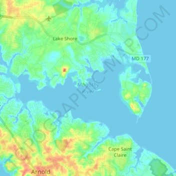
Nome: Mapa topográfico Magothy River, altitude, relevo.
Altitude média: 9 m
Altitude mínima: -3 m
Altitude máxima: 46 m
Almost all of the creeks and tidal coves on the Magothy are named, partly as the result of a project started in 2001 by the Magothy River Association. They are shown on a map produced as part of that project, and the major ones are shown on the USGS topographic map.
Outros mapas topográficos
Clique em um mapa para visualizar sua topografia, sua altitude e seu relevo.
Magothy Forest
United States > Maryland > Anne Arundel County > Severna Park
Magothy Forest, Severna Park, Anne Arundel County, Maryland, 21146, United States
Altitude média: 13 m
Longmeadow North
United States > Maryland > Anne Arundel County > Severna Park
Longmeadow North, Severna Park, Anne Arundel County, Maryland, 21146, United States
Altitude média: 8 m
Linstead-on-the-Severn
United States > Maryland > Anne Arundel County > Severna Park
Linstead-on-the-Severn, Severna Park, Anne Arundel County, Maryland, 21146, United States
Altitude média: 11 m
Severndale
United States > Maryland > Anne Arundel County > Severna Park > Severndale
Severndale, Severna Park, Anne Arundel County, Maryland, 22146, United States
Altitude média: 18 m
Windrush Farm
United States > Maryland > Anne Arundel County > Severna Park > Windrush Farm
Windrush Farm, Severna Park, Anne Arundel County, Maryland, 21012, United States
Altitude média: 10 m
Lower Magothy Beach
United States > Maryland > Anne Arundel County > Severna Park > Lower Magothy Beach
Lower Magothy Beach, Severna Park, Anne Arundel County, Maryland, 21122, United States
Altitude média: 9 m