
Mapa topográfico Annapolis
Mapa interativo
Clique no mapa para exibir a altitude.
Sobre este mapa
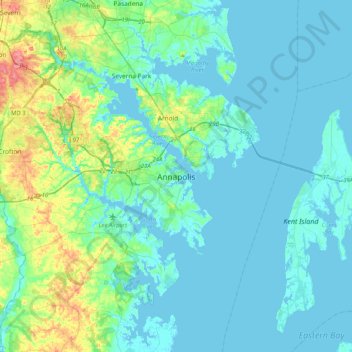
Nome: Mapa topográfico Annapolis, altitude, relevo.
Altitude média: 13 m
Altitude mínima: -3 m
Altitude máxima: 76 m
Annapolis lies within the humid subtropical climate zone (Köppen Cfa), with hot, humid summers, cool winters, and generous precipitation year-round. Low elevation and proximity to the Chesapeake Bay give the area more moderate spring and summertime temperatures and slightly less extreme winter lows than locations further inland, such as Washington, D.C.
Outros mapas topográficos
Clique em um mapa para visualizar sua topografia, sua altitude e seu relevo.
Edgewater
United States > Maryland > Anne Arundel County > Annapolis > Edgewater
Edgewater, Annapolis, Edgewater, Anne Arundel County, Maryland, United States
Altitude média: 7 m
Bay Ridge Junction
United States > Maryland > Anne Arundel County > Annapolis
Bay Ridge Junction, Market Quay, Annapolis, Anne Arundel County, Maryland, 21401, United States
Altitude média: 10 m