
Mapa topográfico Sulawesi
Clique no mapa para exibir a altitude.
Sulawesi
The lowland forests on the island have mostly been removed. Because of the relative geological youth of the island and its dramatic and sharp topography, the lowland areas are naturally limited in their extent. The past decade has seen dramatic conversion of this rare and endangered habitat. The island also possesses one of the largest outcrops of serpentine soil in the world, which support an unusual and large community of specialized plant species. Overall, the flora and fauna of this unique center of global biodiversity is very poorly documented and understood and remains critically threatened.
Sobre este mapa
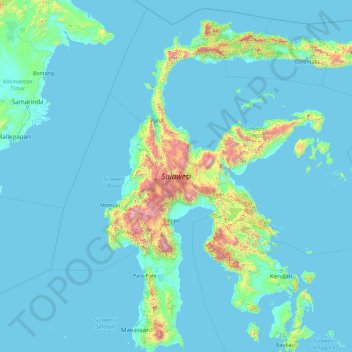
Nome: Mapa topográfico Sulawesi, altitude, relevo.
Local: Sulawesi, Indonesia (-5.70288 118.75714 1.75131 125.24781)
Altitude média: 145 m
Altitude mínima: -3 m
Altitude máxima: 3.405 m
Outros mapas topográficos
Clique em um mapa para visualizar sua topografia, sua altitude e seu relevo.
Malang
Indonesia > East Java > Kota Malang > Malang
The city was capital city of Singhasari in 1222, then transferred to Dutch colony. Malang was modernized under the Dutch; its mild climate which results from its elevation, along with its proximity to the major port of Surabaya, made it a popular destination for the Dutch and other Europeans. Malang began to…
Altitude média: 657 m
Bandung
Bandung (Sundanese: ᮘᮔ᮪ᮓᮥᮀ, romanized: Bandung, Sundanese pronunciation: [ˈbandʊŋ]; /ˈbɑːndʊŋ/) is the capital city of the Indonesian province of West Java. It has a population of 2,452,943 within its city limits according to the official estimates as at mid 2021, making it the fourth most…
Altitude média: 879 m
Bali Island
Bali's central mountains include several peaks over 2,000 metres (6,600 feet) in elevation and active volcanoes such as Mount Batur. The highest is Mount Agung (3,031 m; 9,944 ft), known as the "mother mountain", which is an active volcano rated as one of the world's most likely sites for a massive eruption…
Altitude média: 357 m
Purwokerto
Indonesia > Central Java > Banyumas
Purwokerto is located in the middle of Java Island within the province of Central Java, near the base of Mount Slamet, the second-tallest mountain in Java. The average elevation is 183,87 meters, maximum 286 m, and minimum 71 meters above sea level. The city is bisected by the Kali Kranji (Kranji River). It…
Altitude média: 277 m
Balikpapan
Topography of Balikpapan is generally hilly (85%), with only small areas of flat land (15%), mostly along the coast and surrounding the hilly areas. The hills are less than 100 meters (330 feet) higher than the adjacent valleys. The altitude of Balikpapan ranges from 0 to 80 meters (260 feet) above sea level.…
Altitude média: 10 m
Kepanjen
Indonesia > East Java > Kabupaten Malang
Kepanjen is located in south center of Malang Regency. Kepanjen has an average altitude of 336 metres (1,102 ft) above sea level. Kepanjen is surrounded by three large mountains: Mount Kawi, Mount Semeru and Southern Malang Mountains.
Altitude média: 337 m
Kaliurang
Indonesia > Special Region of Yogyakarta > Sleman Regency > Hargobinangun
Altitude média: 858 m
Babadan
Indonesia > East Java > Kabupaten Malang > Dsn. Babadan, Ds. Babadan, Kecamatan Ngajum, Malang
Altitude média: 561 m
Karimunjawa National Park
The geological formation in the archipelago is mostly dominated by quartz sandstone, gravel, mud, and clay. The topography of Karimunjawa Marine National Park is a wave of low land, with elevation ranging from 0–506 meters above sea level. Gajah hill is the Park’s highest point. Temperatures range from…
Altitude média: 1 m
Waduk Cengklik
Indonesia > Central Java > Boyolali > Desa Ngargorejo > Ngargorejo
Altitude média: 137 m
Bogor
The city is situated in the western part of Java island, about 53 km south of the capital Jakarta and 85 km northwest of Bandung, the administrative center of West Java Province. Bogor spreads over a basin near volcanoes Salak, which peaks at about 12 km south, and Mount Gede whose top is 22–25 km south-east…
Altitude média: 442 m
Dsn. Blau Ds. Permanu Kec. Pakisaji, Malang
Indonesia > East Java > Kabupaten Malang
Altitude média: 478 m
RW 11 Kelurahan Merjosari Kecamatan Lowokwaru Kota Malang
Indonesia > East Java > Kota Malang > Malang
Altitude média: 597 m
Lhokseumawe
Lhokseumawe City is located between 4˚ - 5˚ North Latitude and 96˚ - 97˚ East Longitude with an average altitude of 13 metres above sea level. Lhokseumawe was given the status of an independent city (separate from North Aceh Regency, which surrounds it on all the landward sides) based on Law Number 2 of…
Altitude média: 29 m
Kelurahan Bontoramba, Kecamatan Bontoramba, Kabupaten Jeneponto
Altitude média: 32 m