
Mapa topográfico Canggu
Clique no mapa para exibir a altitude.
Sobre este mapa
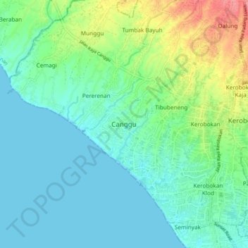
Nome: Mapa topográfico Canggu, altitude, relevo.
Local: Canggu, Badung, Bali, Lesser Sunda Islands, 08456, Indonesia (-8.69062 115.09650 -8.61062 115.17650)
Altitude média: 20 m
Altitude mínima: 0 m
Altitude máxima: 82 m
Outros mapas topográficos
Clique em um mapa para visualizar sua topografia, sua altitude e seu relevo.
Pecatu
Pecatu is located in South Kuta District of the Badung Regency. It is at the western end of the Bukit Peninsula in south Bali, and has a hilly topography with limestone cliffs isolating small, short beaches that have been privately developed. Nusa Dua, on the opposite side of the peninsula, is flat and is a…
Altitude média: 65 m
Ayung River
The Ayung River watershed area has an annual average temperature between 18.4 °C and 26.6 °C, depending on the altitude. The average annual rainfall at the upstream is high, around 1963–3242 mm. Going downstream at an average inclination of 13.13%, the rainfall and the rainy days on the river decrease. In…
Altitude média: 444 m