
Faça uma doação
Mapa topográfico Purwokerto
Clique no mapa para exibir a altitude.
Faça uma doação
Purwokerto
Purwokerto is located in the middle of Java Island within the province of Central Java, near the base of Mount Slamet, the second-tallest mountain in Java. The average elevation is 183,87 meters, maximum 286 m, and minimum 71 meters above sea level. The city is bisected by the Kali Kranji (Kranji River). It lies near two major east–west roads, Sudirman Street and Gatot Subroto Street. Its geographic location is 7°26′S 109°14′E / 7.433°S 109.233°E / -7.433; 109.233.
Faça uma doação
Sobre este mapa
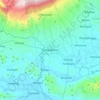
Nome: Mapa topográfico Purwokerto, altitude, relevo.
Local: Purwokerto, Banyumas, Central Java, 53116, Indonesia (-7.58790 109.08085 -7.26790 109.40085)
Altitude média: 277 m
Altitude mínima: -1 m
Altitude máxima: 2.139 m
Faça uma doação
Outros mapas topográficos
Clique em um mapa para visualizar sua topografia, sua altitude e seu relevo.