
Faça uma doação
Mapa topográfico West Tennessee
Clique no mapa para exibir a altitude.
Faça uma doação
West Tennessee
West Tennessee is located almost entirely within the Mississippi Embayment, part of the Gulf Coastal Plain. Because of this, the terrain is flatter than the eastern parts of the state. Areas along the Mississippi River are located within the Mississippi Alluvial Plain, which is primarily a floodplain with many swamps. However, much of the western counties of the region are protected from flooding by the Chickasaw Bluffs, ridges of loess rising 50 to 200 feet (15 to 61 m) above the floodplain. Although the land is lower and flatter than Middle and East Tennessee, some hilly terrain exists, especially along the bluffs bordering the Mississippi River and the land bordering the Tennessee River, known as the West Tennessee Highlands. Hilly land in these areas is forested. Otherwise, most of the land in West Tennessee is used as farmland. The soil in this part of the state comes from when a prehistoric sea dried up and left sediment in its place. Unlike in the rest of the state, bedrock is buried a few thousand feet below the surface. West Tennessee's highest elevation is approximately 840 feet (260 m) in Hardin County east of the Tennessee River, which is slightly lower than the state's mean elevation of 900 feet (270 m); the region's highest elevation west of the Tennessee River is approximately 740 feet (230 m) in Chester County.
Faça uma doação
Sobre este mapa
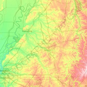
Nome: Mapa topográfico West Tennessee, altitude, relevo.
Local: West Tennessee, Tennessee, United States (34.99372 -90.31030 36.50723 -87.91657)
Altitude média: 127 m
Altitude mínima: 56 m
Altitude máxima: 325 m
Faça uma doação
Outros mapas topográficos
Clique em um mapa para visualizar sua topografia, sua altitude e seu relevo.
Faça uma doação
Faça uma doação
Staffordtown
United States > Tennessee > Polk County > Copperhill
Staffordtown is situated in the scenic Appalachian region, characterized by its rugged terrain and lush forests. The area is marked by steep hills and rolling valleys that define the landscape, with elevations ranging from around 1,500 to 3,000 feet above sea level. The surrounding mountains, part of the…
Altitude média: 478 m
Faça uma doação
Fall Creek Falls State Park
United States > Tennessee > Van Buren County
Just beyond its source, Cane Creek slowly gains strength as it absorbs Meadow Creek and several smaller streams. As the creek enters the gorge, it drops several hundred feet in less than a mile, including 45 feet (14 m) over Cane Creek Cascades and 85 feet (26 m) over Cane Creek Falls. A few hundred meters…
Altitude média: 524 m
Faça uma doação
Faça uma doação
Faça uma doação
Faça uma doação
Faça uma doação
Faça uma doação
Faça uma doação
Faça uma doação
Faça uma doação
Faça uma doação
Faça uma doação
Faça uma doação
Faça uma doação
Faça uma doação
Faça uma doação
Faça uma doação
Faça uma doação
Lockeland Springs Park
United States > Tennessee > Davidson County > Nashville-Davidson
Altitude média: 149 m
Faça uma doação
Faça uma doação
Faça uma doação
Faça uma doação
Henry Horton State Park
United States > Tennessee > Marshall County > Chapel Hill
Altitude média: 207 m
Faça uma doação