
Obrigado por apoiar este site ❤️
Faça uma doação
Faça uma doação
Mapa topográfico Walnut Grove
Clique no mapa para exibir a altitude.
Obrigado por apoiar este site ❤️
Faça uma doação
Faça uma doação
Sobre este mapa
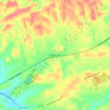
Nome: Mapa topográfico Walnut Grove, altitude, relevo.
Altitude média: 334 m
Altitude mínima: 287 m
Altitude máxima: 375 m
Obrigado por apoiar este site ❤️
Faça uma doação
Faça uma doação
Outros mapas topográficos
Clique em um mapa para visualizar sua topografia, sua altitude e seu relevo.
Douglas Dam
United States > Tennessee > Sevier County
The Douglas Project required the construction of ten smaller, earthen saddle dams to fill in gaps along the adjacent ridgeline and permit a higher water elevation than would otherwise be possible. Most of these saddle dams are located in the hills southeast of the main dam. One protects downtown Dandridge,…
Altitude média: 312 m