
Faça uma doação
Mapa topográfico Bacliff
Clique no mapa para exibir a altitude.
Faça uma doação
Bacliff
After Hurricane Ike hit Texas in September 2008, Galveston County officials offered a debris removal program to residents in unincorporated areas, including Bacliff. Flooding from hurricane Ike was minimized due in part to Bacliff's relatively high elevation of 16 feet.
Faça uma doação
Sobre este mapa
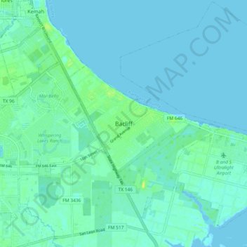
Nome: Mapa topográfico Bacliff, altitude, relevo.
Local: Bacliff, Galveston County, Texas, 77518, United States (29.46632 -95.02775 29.54632 -94.94775)
Altitude média: 4 m
Altitude mínima: -1 m
Altitude máxima: 15 m
Faça uma doação
Outros mapas topográficos
Clique em um mapa para visualizar sua topografia, sua altitude e seu relevo.
Galveston
United States > Texas > Galveston County
On September 8, 1900, the island was struck by a devastating hurricane. This event holds the record as the United States' deadliest natural disaster. The city was devastated, and an estimated 6,000 to 8,000 people on the island were killed. Following the storm, a 10-mile (16 km) long, 17 foot (5.2 m) high…
Altitude média: 1 m
Faça uma doação
Galveston
United States > Texas > Galveston County
On September 8, 1900, the island was struck by a devastating hurricane. This event holds the record as the United States' deadliest natural disaster. The city was devastated, and an estimated 6,000 to 8,000 people on the island were killed. Following the storm, a 10-mile (16 km) long, 17 foot (5.2 m) high…
Altitude média: 1 m
Texas City
United States > Texas > Galveston County
Officially, the elevation of Texas City is 10 feet above sea level, though some areas are even lower. It was naturally vulnerable to flooding by hurricane storm surges and heavy rainstorms.
Altitude média: 2 m
Faça uma doação
Faça uma doação
Galveston
United States > Texas > Galveston County
On September 8, 1900, the island was struck by a devastating hurricane. This event holds the record as the United States' deadliest natural disaster. The city was devastated, and an estimated 6,000 to 8,000 people on the island were killed. Following the storm, a 10-mile (16 km) long, 17 foot (5.2 m) high…
Altitude média: 1 m
Faça uma doação
Texas City
United States > Texas > Galveston County
Officially, the elevation of Texas City is 10 feet above mean sea level, though some areas are even lower. It was naturally vulnerable to flooding by hurricane storm surges and heavy rainstorms.
Altitude média: 2 m
Galveston
United States > Texas > Galveston County
On September 8, 1900, the island was struck by a devastating hurricane. This event holds the record as the United States' deadliest natural disaster. The city was devastated, and an estimated 6,000 to 8,000 people on the island were killed. Following the storm, a 10-mile (16 km) long, 17 foot (5.2 m) high…
Altitude média: 1 m
Faça uma doação
Galveston
United States > Texas > Galveston County
On September 8, 1900, the island was struck by a devastating hurricane. This event holds the record as the United States' deadliest natural disaster. The city was devastated, and an estimated 6,000 to 8,000 people on the island were killed. Following the storm, a 10-mile (16 km) long, 17 foot (5.2 m) high…
Altitude média: 1 m
Texas City
United States > Texas > Galveston County
Officially, the elevation of Texas City is 10 feet above sea level, though some areas are even lower. It was naturally vulnerable to flooding by hurricane storm surges and heavy rainstorms.
Altitude média: 2 m
Faça uma doação
Faça uma doação