
Faça uma doação
Mapa topográfico La Marque
Clique no mapa para exibir a altitude.
Faça uma doação
Sobre este mapa
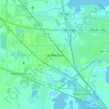
Nome: Mapa topográfico La Marque, altitude, relevo.
Local: La Marque, Galveston County, Texas, 77568, United States (29.32713 -95.06456 29.41101 -94.92904)
Altitude média: 4 m
Altitude mínima: -9 m
Altitude máxima: 21 m
Faça uma doação
Outros mapas topográficos
Clique em um mapa para visualizar sua topografia, sua altitude e seu relevo.
Faça uma doação
San Luis Pass
United States > Texas > Galveston County > Galveston
Tides cause daily variations in topography, and occasionally, storms more drastically change the topography of the pass.
Altitude média: 0 m
Faça uma doação
Bacliff
United States > Texas > Galveston County
After Hurricane Ike hit Texas in September 2008, Galveston County officials offered a debris removal program to residents in unincorporated areas, including Bacliff. Flooding from hurricane Ike was minimized due in part to Bacliff's relatively high elevation of 16 feet.
Altitude média: 4 m
Faça uma doação