
Faça uma doação
Mapa topográfico Eversholt
Clique no mapa para exibir a altitude.
Faça uma doação
Sobre este mapa
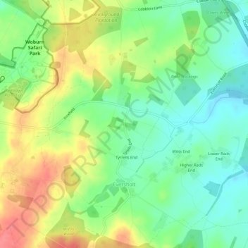
Nome: Mapa topográfico Eversholt, altitude, relevo.
Local: Eversholt, Central Bedfordshire, England, United Kingdom (51.97466 -0.58856 52.00746 -0.53791)
Altitude média: 117 m
Altitude mínima: 88 m
Altitude máxima: 157 m
Faça uma doação
Outros mapas topográficos
Clique em um mapa para visualizar sua topografia, sua altitude e seu relevo.
Lower Caldecote
United Kingdom > England > Central Bedfordshire > Upper Caldecote
Altitude média: 32 m
Faça uma doação
Dunstable Downs
United Kingdom > England > Central Bedfordshire > Church End
Because of its elevation, Dunstable Downs hosted a station in the shutter telegraph chain which connected the Admiralty in London to its naval ships in the port of Great Yarmouth during the years 1808 to 1814.
Altitude média: 178 m
Edgecote
United Kingdom > England > Central Bedfordshire > Caddington > Aley Green
Altitude média: 168 m
Faça uma doação
Houghton Hall Park
United Kingdom > England > Central Bedfordshire > Houghton Regis
Altitude média: 134 m
Faça uma doação
Faça uma doação
Faça uma doação
Faça uma doação
Dog Kennel Down
United Kingdom > England > Central Bedfordshire > Houghton Regis
Altitude média: 138 m
Faça uma doação
Faça uma doação
Totternhoe Knolls
United Kingdom > England > Central Bedfordshire > Church End > Lower End
Altitude média: 105 m
Crawley Park
United Kingdom > England > Central Bedfordshire > Aspley Guise > Husborne Crawley
Altitude média: 98 m
Faça uma doação