
Faça uma doação
Mapa topográfico Lower Stondon
Clique no mapa para exibir a altitude.
Faça uma doação
Sobre este mapa
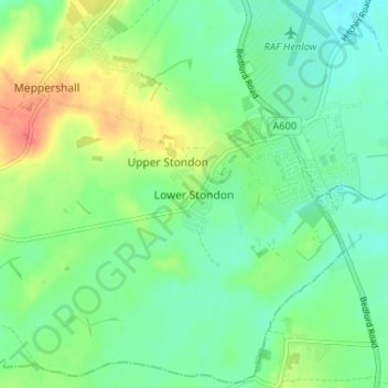
Nome: Mapa topográfico Lower Stondon, altitude, relevo.
Altitude média: 57 m
Altitude mínima: 39 m
Altitude máxima: 92 m
Faça uma doação
Outros mapas topográficos
Clique em um mapa para visualizar sua topografia, sua altitude e seu relevo.
Northill
United Kingdom > England > Central Bedfordshire
Topographically, Northill stands on a slightly elevated ridge that runs north to south. The village lies on the border of the Bedfordshire and Cambridgeshire Claylands and the Bedfordshire Greensand Ridge; National Character Areas designated by Natural England. Central Bedfordshire Council has classified the…
Altitude média: 37 m
Dog Kennel Down
United Kingdom > England > Central Bedfordshire > Houghton Regis
Altitude média: 138 m
Faça uma doação
Faça uma doação
Faça uma doação
Faça uma doação
Faça uma doação
Faça uma doação
Dunstable Downs
United Kingdom > England > Central Bedfordshire > Church End
Because of its elevation, Dunstable Downs hosted a station in the shutter telegraph chain which connected the Admiralty in London to its naval ships in the port of Great Yarmouth during the years 1808 to 1814.
Altitude média: 178 m
Faça uma doação
Edgecote
United Kingdom > England > Central Bedfordshire > Caddington > Aley Green
Altitude média: 168 m
Houghton Hall Park
United Kingdom > England > Central Bedfordshire > Houghton Regis
Altitude média: 134 m
Faça uma doação
Faça uma doação
Faça uma doação
Faça uma doação
Faça uma doação
Faça uma doação
Faça uma doação
Faça uma doação
Faça uma doação
Wrestlingworth and Cockayne Hatley
United Kingdom > England > Central Bedfordshire
Altitude média: 51 m
Faça uma doação
Faça uma doação
Husborne Crawley
United Kingdom > England > Central Bedfordshire > Husborne Crawley
Altitude média: 97 m
Faça uma doação
Faça uma doação
Totternhoe Knolls
United Kingdom > England > Central Bedfordshire > Church End > Lower End
Altitude média: 105 m
Faça uma doação
Faça uma doação
Crawley Park
United Kingdom > England > Central Bedfordshire > Aspley Guise > Husborne Crawley
Altitude média: 98 m
Faça uma doação