
Mapa topográfico Long Beach
Clique no mapa para exibir a altitude.
Long Beach
Willow Springs Park was founded as a part of the Willow Springs Wetlands Restoration Project which opened in October 2017. The project restored 11 acres of a 48-acre degraded oil well site into wetlands. These highlight the pivotal role the ecosystem played in the City of Long Beach’s establishment in the late 1800’s and helps preserve the site's history and unique topography. It is now at about 16 acres restored and, in August 2024, it began the process of being dedicated as a open space by the city council, which will make it the largest green space in Central Long Beach once done. It is run in collaboration with the city's office of Climate Action and Sustainability which was established in 2008 to support and advance environmental stewardship and equity in the City of Long Beach.
Sobre este mapa
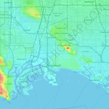
Nome: Mapa topográfico Long Beach, altitude, relevo.
Local: Long Beach, Los Angeles County, California, United States (33.69058 -118.24897 33.88556 -118.06329)
Altitude média: 12 m
Altitude mínima: -5 m
Altitude máxima: 129 m
Outros mapas topográficos
Clique em um mapa para visualizar sua topografia, sua altitude e seu relevo.
San Fernando Valley
United States > California > Los Angeles County > Los Angeles
Altitude média: 496 m
Santa Monica Mountains
United States > California > Los Angeles County
On January 17, 2007, an unusually cold storm brought snow in the Santa Monica Mountains. The hills above Malibu picked up three inches (eight centimeters) of snow - the first measurable snow in fifty years. Snow was reported on Boney Peak in the winter of 2005; and in March 2006, snow also fell on the summit…
Altitude média: 201 m
Mount San Antonio
United States > California > Los Angeles County
The prehistoric Hog Back landslide lies in the canyon of San Antonio Creek at 4000' elevation. When the slide occurred, it dammed the river, whose depth built up until the water was released catastrophically, forming a slot canyon which now holds some of the area's few good rock climbing routes (difficulty…
Altitude média: 2.675 m
Universal City Overlook
United States > California > Los Angeles County > Los Angeles
Altitude média: 278 m
Green Valley
United States > California > Los Angeles County
Green Valley is an unincorporated community and census-designated place (CDP) in the Sierra Pelona Mountains, in Los Angeles County, California. It lies at an elevation of 2936 feet (895 m). The population was 1,036 at the 2020 census, up from 1,027 at the 2010 census.
Altitude média: 1.057 m
Santa Monica Mountains
United States > California > Los Angeles County > Unincorporated Santa Monica Mountains
On January 17, 2007, an unusually cold storm brought snow in the Santa Monica Mountains. The hills above Malibu picked up three inches (eight centimeters) of snow - the first measurable snow in fifty years. Snow was reported on Boney Peak in the winter of 2005; and in March 2006, snow also fell on the summit…
Altitude média: 304 m
Mount Baden-Powell
United States > California > Los Angeles County
At 9,407 feet (2,867 m) in elevation, Mount Baden-Powell is traditionally considered to be the 5th highest peak of the San Gabriel Range; however it is the second highest peak in the range with more than 1,000 feet (300 m) of prominence, and is the highest peak not part of the Mount San Antonio massif.
Altitude média: 2.429 m
West Puente Valley
United States > California > Los Angeles County > West Puente Valley
Altitude média: 101 m
Point Dume
United States > California > Los Angeles County > Malibu
Offshore, the nutrient-rich and frigid waters of the Pacific enhance the entire marine food web, from primary producers such as algae and zooplankton to apex predators like sand sharks, bottlenose dolphins, and gray whales. Within the Marine Protected Areas (MPAs), the diverse seafloor topography encompasses…
Altitude média: 12 m
Portuguese Bend
United States > California > Los Angeles County > Rancho Palos Verdes
Altitude média: 66 m
Oak Hill
United States > California > Los Angeles County > Unincorporated Santa Monica Mountains
Altitude média: 478 m
Oak Spring Canyon Park
United States > California > Los Angeles County > Santa Clarita
Altitude média: 519 m
Little Jimmy Spring
United States > California > Los Angeles County > Cedar Springs
Altitude média: 2.188 m
San Fernando Valley
United States > California > Los Angeles County > Los Angeles
Altitude média: 496 m
Green Valley
United States > California > Los Angeles County
Green Valley is an unincorporated community and census-designated place (CDP) in the Sierra Pelona Mountains, in Los Angeles County, California. It lies at an elevation of 2936 feet (895 m). The population was 1,036 at the 2020 census, up from 1,027 at the 2010 census.
Altitude média: 1.057 m
Mount San Antonio
United States > California > Los Angeles County
The prehistoric Hog Back landslide lies in the canyon of San Antonio Creek at 4000' elevation. When the slide occurred, it dammed the river, whose depth built up until the water was released catastrophically, forming a slot canyon which now holds some of the area's few good rock climbing routes (difficulty…
Altitude média: 2.675 m
Santa Susana Mountains
United States > California > Los Angeles County > Los Angeles
Altitude média: 520 m
Cornell
United States > California > Los Angeles County > Unincorporated Santa Monica Mountains
Altitude média: 333 m
Point Dume
United States > California > Los Angeles County > Malibu
Offshore, the nutrient-rich and frigid waters of the Pacific enhance the entire marine food web, from primary producers such as algae and zooplankton to apex predators like sand sharks, bottlenose dolphins, and gray whales. Within the Marine Protected Areas (MPAs), the diverse seafloor topography encompasses…
Altitude média: 12 m
Lake Elizabeth
United States > California > Los Angeles County
The lake, at 3,228 ft (984 m) in elevation, is within the Angeles National Forest. It is a natural perennial lake, but may dry up entirely during drought years. It is south of the western Antelope Valley.
Altitude média: 1.065 m
Malibu Vista
United States > California > Los Angeles County > Unincorporated Santa Monica Mountains
Altitude média: 283 m
Twin Lakes
United States > California > Los Angeles County > Unincorporated Chatsworth
Altitude média: 400 m
Eaton Canyon Waterfall
United States > California > Los Angeles County > Pasadena
Altitude média: 639 m
Will Rogers State Historic Park
United States > California > Los Angeles County > Los Angeles
Altitude média: 152 m
Mount Baden-Powell
United States > California > Los Angeles County
At 9,407 feet (2,867 m) in elevation, Mount Baden-Powell is traditionally considered to be the 5th highest peak of the San Gabriel Range; however it is the second highest peak in the range with more than 1,000 feet (300 m) of prominence, and is the highest peak not part of the Mount San Antonio massif.
Altitude média: 2.429 m
Monte Nido
United States > California > Los Angeles County > Unincorporated Santa Monica Mountains
Altitude média: 327 m
Veterans Administration
United States > California > Los Angeles County > Veterans Administration
Altitude média: 105 m
Santa Susana Mountains
United States > California > Los Angeles County > Unincorporated Chatsworth
Altitude média: 546 m
Twin Lakes
United States > California > Los Angeles County > Unincorporated Chatsworth
Altitude média: 400 m
Altacanyada
United States > California > Los Angeles County > La Cañada Flintridge
Altitude média: 584 m
Mount San Antonio
United States > California > Los Angeles County
The prehistoric Hog Back landslide lies in the canyon of San Antonio Creek at 4000' elevation. When the slide occurred, it dammed the river, whose depth built up until the water was released catastrophically, forming a slot canyon which now holds some of the area's few good rock climbing routes (difficulty…
Altitude média: 2.675 m
Horsethief Canyon Park
United States > California > Los Angeles County > San Dimas
Altitude média: 373 m