
Mapa topográfico Thenard
Clique no mapa para exibir a altitude.
Sobre este mapa
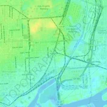
Nome: Mapa topográfico Thenard, altitude, relevo.
Altitude média: 8 m
Altitude mínima: -1 m
Altitude máxima: 22 m
Outros mapas topográficos
Clique em um mapa para visualizar sua topografia, sua altitude e seu relevo.
Valley Village Neighborhood Council District
United States > California > Los Angeles County > Los Angeles
Altitude média: 199 m
Studio City Neighborhood Council District
United States > California > Los Angeles County > Los Angeles
Altitude média: 255 m
Canoga Park Neighborhood Council District
United States > California > Los Angeles County > Los Angeles
Altitude média: 255 m
Porter Ranch Neighborhood Council District
United States > California > Los Angeles County > Los Angeles
Altitude média: 460 m
Van Nuys Neighborhood Council District
United States > California > Los Angeles County > Los Angeles
Altitude média: 224 m
Arleta Neighborhood Council District
United States > California > Los Angeles County > Los Angeles
Altitude média: 274 m
Winnetka Neighborhood Council District
United States > California > Los Angeles County > Los Angeles
Altitude média: 244 m
Sherman Oaks Neighborhood Council District
United States > California > Los Angeles County > Los Angeles
Altitude média: 257 m
Chatsworth Neighborhood Council District
United States > California > Los Angeles County > Los Angeles
Altitude média: 360 m
North Hollywood Neighborhood Council District
United States > California > Los Angeles County > Los Angeles
Altitude média: 196 m
Encino Neighborhood Council District
United States > California > Los Angeles County > Los Angeles
Altitude média: 288 m
Pacoima Neighborhood Council
United States > California > Los Angeles County > Los Angeles
Altitude média: 312 m
Pacific Palisades
United States > California > Los Angeles County > Los Angeles
Pacific Palisades was formally founded in 1921 by a Methodist organization, and in the years that followed became a refuge for Jewish artists and intellectuals fleeing the Holocaust. The Palisades would later be sought after by celebrities and other high-profile individuals seeking privacy. It is known for its…
Altitude média: 196 m
Lake Balboa Neighborhood Council District
United States > California > Los Angeles County > Los Angeles
Altitude média: 230 m
Santa Susana Mountains
United States > California > Los Angeles County > Los Angeles
Altitude média: 520 m
Chatsworth Neighborhood Council District
United States > California > Los Angeles County > Los Angeles
Altitude média: 360 m
Sherman Oaks Neighborhood Council District
United States > California > Los Angeles County > Los Angeles
Altitude média: 257 m
Will Rogers State Historic Park
United States > California > Los Angeles County > Los Angeles
Altitude média: 152 m
Valley Village Neighborhood Council District
United States > California > Los Angeles County > Los Angeles
Altitude média: 199 m
Los Angeles City Council District 11
United States > California > Los Angeles County > Los Angeles
Altitude média: 141 m
Chatsworth Neighborhood Council District
United States > California > Los Angeles County > Los Angeles
Altitude média: 361 m
Van Nuys Neighborhood Council District
United States > California > Los Angeles County > Los Angeles
Altitude média: 224 m
Chatsworth Neighborhood Council District
United States > California > Los Angeles County > Los Angeles
Altitude média: 360 m
North Hollywood Neighborhood Council District
United States > California > Los Angeles County > Los Angeles
Altitude média: 196 m
Chatsworth Neighborhood Council District
United States > California > Los Angeles County > Los Angeles
Altitude média: 360 m
Los Angeles City Council District 7
United States > California > Los Angeles County > Los Angeles
Altitude média: 512 m
Rio de Los Angeles State Park State Recreational Area
United States > California > Los Angeles County > Los Angeles
Altitude média: 141 m