
Mapa topográfico Point Dume
Clique no mapa para exibir a altitude.
Point Dume
Offshore, the nutrient-rich and frigid waters of the Pacific enhance the entire marine food web, from primary producers such as algae and zooplankton to apex predators like sand sharks, bottlenose dolphins, and gray whales. Within the Marine Protected Areas (MPAs), the diverse seafloor topography encompasses hills, valleys, grooves, and channels, creating optimal habitats for species such as white seabass, giant sea bass, kelp bass, and lobster. Commonly, harbor seals, sea lions, and dolphins frequent these areas. From February on into the spring, humpback and gray whales, particularly newborn whale calves, are frequently observed as they undertake their coastal migrations.
Sobre este mapa
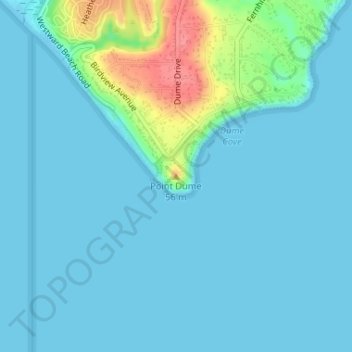
Nome: Mapa topográfico Point Dume, altitude, relevo.
Altitude média: 12 m
Altitude mínima: -3 m
Altitude máxima: 77 m
Outros mapas topográficos
Clique em um mapa para visualizar sua topografia, sua altitude e seu relevo.