
Faça uma doação
Mapa topográfico Porter
Clique no mapa para exibir a altitude.
Faça uma doação
Sobre este mapa
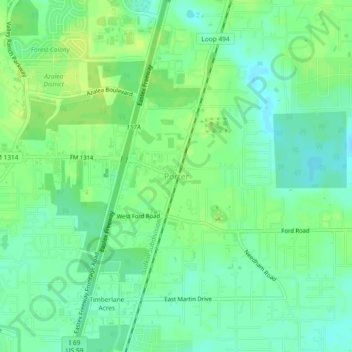
Nome: Mapa topográfico Porter, altitude, relevo.
Local: Porter, Montgomery County, Texas, 77365, United States (30.08244 -95.24966 30.12244 -95.20966)
Altitude média: 30 m
Altitude mínima: 22 m
Altitude máxima: 37 m
Faça uma doação
Outros mapas topográficos
Clique em um mapa para visualizar sua topografia, sua altitude e seu relevo.
Conroe
United States > Texas > Montgomery County
Conroe features a predominantly flat terrain with an average elevation of approximately 220 feet (67 meters) above sea level. The area is characterized by gently rolling hills interspersed with numerous lakes and wetlands, including the prominent Lake Conroe, which spans about 21,000 acres. The lake, formed by…
Altitude média: 62 m
The Woodlands
United States > Texas > Montgomery County
The Woodlands is in a heavily forested area, and much of the community has retained trees for shade and decoration. The terrain is essentially flat, with the exception of topographic variations ranging from 125 to 175 feet above sea level between Spring Creek and Flintridge Drive.
Altitude média: 47 m
Faça uma doação
The Woodlands
United States > Texas > Montgomery County
It is in a heavily forested area, and much of the community has retained trees for shade and decoration. The terrain is essentially flat, with the exception of topographic variations ranging from 125 to 175 feet between Spring Creek and Flintridge Drive.
Altitude média: 47 m
Faça uma doação
Faça uma doação
Faça uma doação
Faça uma doação
Faça uma doação
Faça uma doação
Faça uma doação