
Obrigado por apoiar este site ❤️
Faça uma doação
Faça uma doação
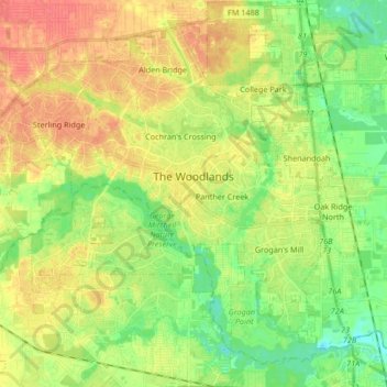
Mapa topográfico The Woodlands
Clique no mapa para exibir a altitude.
Obrigado por apoiar este site ❤️
Faça uma doação
Faça uma doação
The Woodlands
The Woodlands is in a heavily forested area, and much of the community has retained trees for shade and decoration. The terrain is essentially flat, with the exception of topographic variations ranging from 125 to 175 feet above sea level between Spring Creek and Flintridge Drive.
Obrigado por apoiar este site ❤️
Faça uma doação
Faça uma doação
Sobre este mapa
Nome: Mapa topográfico The Woodlands, altitude, relevo.
Local: The Woodlands, Montgomery County, Texas, United States (30.10304 -95.60118 30.23057 -95.43430)
Altitude média: 47 m
Altitude mínima: 23 m
Altitude máxima: 72 m
Obrigado por apoiar este site ❤️
Faça uma doação
Faça uma doação
Outros mapas topográficos
Clique em um mapa para visualizar sua topografia, sua altitude e seu relevo.
Obrigado por apoiar este site ❤️
Faça uma doação
Faça uma doação
Obrigado por apoiar este site ❤️
Faça uma doação
Faça uma doação
Obrigado por apoiar este site ❤️
Faça uma doação
Faça uma doação
Obrigado por apoiar este site ❤️
Faça uma doação
Faça uma doação