
Faça uma doação
Mapa topográfico Conroe
Clique no mapa para exibir a altitude.
Faça uma doação
Conroe
Conroe features a predominantly flat terrain with an average elevation of approximately 220 feet (67 meters) above sea level. The area is characterized by gently rolling hills interspersed with numerous lakes and wetlands, including the prominent Lake Conroe, which spans about 21,000 acres. The lake, formed by the Conroe Dam, contributes to the local ecosystem and recreational opportunities, providing a habitat for diverse wildlife. Surrounding the city, you'll find lush forests, notably the Sam Houston National Forest to the east, which adds to the scenic beauty and biodiversity of the region. This combination of water bodies and wooded areas creates a picturesque landscape, making Conroe an attractive place for both residents and visitors.
Faça uma doação
Sobre este mapa
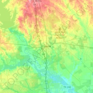
Nome: Mapa topográfico Conroe, altitude, relevo.
Local: Conroe, Montgomery County, Texas, United States (30.20266 -95.65670 30.41999 -95.39094)
Altitude média: 62 m
Altitude mínima: 27 m
Altitude máxima: 123 m
Faça uma doação
Outros mapas topográficos
Clique em um mapa para visualizar sua topografia, sua altitude e seu relevo.
Faça uma doação
Faça uma doação
Faça uma doação
Faça uma doação