
Mapa topográfico Bramshall
Clique no mapa para exibir a altitude.
Sobre este mapa
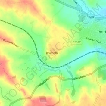
Nome: Mapa topográfico Bramshall, altitude, relevo.
Altitude média: 121 m
Altitude mínima: 86 m
Altitude máxima: 165 m
Outros mapas topográficos
Clique em um mapa para visualizar sua topografia, sua altitude e seu relevo.
Shobnall
United Kingdom > England > Staffordshire > East Staffordshire > Burton-on-Trent
Altitude média: 56 m
Tutbury Castle
United Kingdom > England > Staffordshire > East Staffordshire > Tutbury
Altitude média: 66 m
Barton-under-Needwood
United Kingdom > England > Staffordshire > East Staffordshire > Barton-under-Needwood
Altitude média: 69 m
Draycott in the Clay
United Kingdom > England > Staffordshire > East Staffordshire
Altitude média: 90 m
Blithfield Reservoir
United Kingdom > England > Staffordshire > East Staffordshire > Admaston
Altitude média: 108 m
Mayfield
United Kingdom > England > Staffordshire > East Staffordshire > Mayfield
Altitude média: 156 m
Hanbury
United Kingdom > England > Staffordshire > East Staffordshire
This locality adjoins the River Dove and includes a steep knoll between much of it and the river, Row Hill; five listed buildings are here all at Grade II. Hanbury's village centre is 0.9 miles (1.4 km) to the south. This hamlet is at an elevation of 61m AOD whereas the village centre of Hanbury is at the…
Altitude média: 107 m
Harlow Wood
United Kingdom > England > Staffordshire > East Staffordshire > Upper Mayfield
Altitude média: 177 m