
Faça uma doação
Mapa topográfico Hanbury
Clique no mapa para exibir a altitude.
Faça uma doação
Hanbury
This locality adjoins the River Dove and includes a steep knoll between much of it and the river, Row Hill; five listed buildings are here all at Grade II. Hanbury's village centre is 0.9 miles (1.4 km) to the south. This hamlet is at an elevation of 61m AOD whereas the village centre of Hanbury is at the start of a steep westward valley at the source of the Salt Brook at 134m AOD.
Faça uma doação
Sobre este mapa
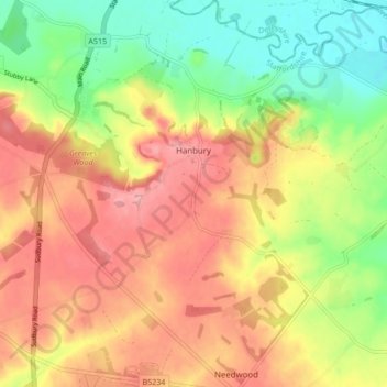
Nome: Mapa topográfico Hanbury, altitude, relevo.
Altitude média: 107 m
Altitude mínima: 52 m
Altitude máxima: 155 m
Faça uma doação
Outros mapas topográficos
Clique em um mapa para visualizar sua topografia, sua altitude e seu relevo.
Tutbury Castle
United Kingdom > England > Staffordshire > East Staffordshire > Tutbury
Altitude média: 66 m
Burton upon Trent
United Kingdom > England > Staffordshire > East Staffordshire
Burton is about 109 miles (175 km) north west of London, about 30 miles north east of Birmingham, the UK's second largest city and about 23 miles east of the county town Stafford. It is at the easternmost border of the county of Staffordshire with Derbyshire, its suburbs and the course of the River Trent…
Altitude média: 69 m
Stubwood
United Kingdom > England > Staffordshire > East Staffordshire > Denstone
Altitude média: 113 m
Birch Cross
United Kingdom > England > Staffordshire > East Staffordshire > Marchington
Altitude média: 92 m
Faça uma doação
Gratwich
United Kingdom > England > Staffordshire > East Staffordshire > Kingstone
Altitude média: 143 m
Faça uma doação
Marchington Woodlands
United Kingdom > England > Staffordshire > East Staffordshire
Altitude média: 120 m
Blithfield Reservoir
United Kingdom > England > Staffordshire > East Staffordshire > Admaston
Altitude média: 108 m
Faça uma doação
Harlow Wood
United Kingdom > England > Staffordshire > East Staffordshire > Upper Mayfield
Altitude média: 177 m
Burton upon Trent
United Kingdom > England > Staffordshire > East Staffordshire
Burton is about 109 miles (175 km) north west of London, about 30 miles north east of Birmingham, the UK's second largest city and about 23 miles east of the county town Stafford. It is at the easternmost border of the county of Staffordshire with Derbyshire, its suburbs and the course of the River Trent…
Altitude média: 69 m
Faça uma doação