Mapa topográfico Millendon
Mapa interativo
Clique no mapa para exibir a altitude.
Sobre este mapa
![Mapa topográfico Millendon, altitude, relevo](/pub/maps/relation/kmnh/czxwzs/thumbnail.jpg)
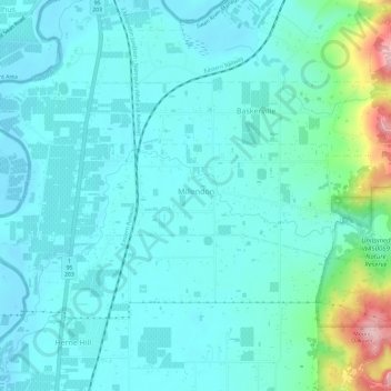
Nome: Mapa topográfico Millendon, altitude, relevo.
Local: Millendon, City of Swan, Western Australia, Australia (-31.81613 116.00443 -31.80002 116.06474)
Altitude média: 40 m
Altitude mínima: 2 m
Altitude máxima: 231 m
Outros mapas topográficos
Clique em um mapa para visualizar sua topografia, sua altitude e seu relevo.
![Mapa topográfico Perth, altitude, relevo](/pub/maps/node/dfgp/49kxmnh/icon.jpg)
Perth
Australia > Western Australia > City of Perth
Perth, City of Perth, Western Australia, 6000, Australia
Altitude média: 26 m
![Mapa topográfico City of Perth, altitude, relevo](/pub/maps/relation/3lnh/xthmdn/icon.jpg)
City of Perth
City of Perth, Western Australia, Australia
Altitude média: 18 m
![Mapa topográfico Swan River, altitude, relevo](/pub/maps/relation/3551/9rk63l/icon.jpg)
Swan River
Australia > Western Australia > City of Perth
Swan River, City of Perth, Western Australia, Australia
Altitude média: 57 m
![Mapa topográfico East Bunbury, altitude, relevo](/pub/maps/relation/gjzs/wxsjmt/icon.jpg)
East Bunbury
East Bunbury, City Of Bunbury, Western Australia, Australia
Altitude média: 7 m
![Mapa topográfico Albany, altitude, relevo](/pub/maps/node/gfzs/l7ql8ms8/icon.jpg)
Albany
Albany, City Of Albany, Western Australia, 6330, Australia
Altitude média: 30 m
![Mapa topográfico Logue Brook Dam, altitude, relevo](/pub/maps/way/4prr/mmsln9z4/icon.jpg)
Logue Brook Dam
Logue Brook Dam, Shire Of Harvey, Western Australia, Australia
Altitude média: 242 m
![Mapa topográfico Darkan, altitude, relevo](/pub/maps/relation/wtb3/flpccz/icon.jpg)
Darkan
Darkan, Shire Of West Arthur, Western Australia, Australia
Altitude média: 290 m
![Mapa topográfico Lake Brockman, altitude, relevo](/pub/maps/way/3h51/sjsqx9m/icon.jpg)
Lake Brockman
Lake Brockman, Shire Of Harvey, Western Australia, Australia
Altitude média: 244 m
![Mapa topográfico Fremantle, altitude, relevo](/pub/maps/node/w1b3/4bp74nh/icon.jpg)
Fremantle
Australia > Western Australia > City of Fremantle > Fremantle
Fremantle, City of Fremantle, Western Australia, 6959, Australia
Altitude média: 11 m
![Mapa topográfico Busselton, altitude, relevo](/pub/maps/node/f2gt/gktt95k/icon.jpg)
Busselton
Busselton, City Of Busselton, Western Australia, Australia
Altitude média: 4 m
![Mapa topográfico Geraldton, altitude, relevo](/pub/maps/node/hstj/ft7g13l/icon.jpg)
Geraldton
Geraldton, City Of Greater Geraldton, Western Australia, 6530, Australia
Altitude média: 33 m
![Mapa topográfico Rottnest Island, altitude, relevo](/pub/maps/relation/h3m2/5zsw3l/icon.jpg)
Rottnest Island
Australia > Western Australia > Geordie Bay
Rottnest Island, Geordie Bay, City Of Cockburn, Western Australia, 6161, Australia
Altitude média: 2 m
![Mapa topográfico Mandurah, altitude, relevo](/pub/maps/node/t23q/scs98f3/icon.jpg)
Mandurah
Mandurah, City Of Mandurah, Western Australia, 6201, Australia
Altitude média: 5 m
![Mapa topográfico Esperance, altitude, relevo](/pub/maps/node/3d1h/dkzr894s/icon.jpg)
Esperance
Esperance, Shire Of Esperance, Western Australia, Australia
Altitude média: 8 m
![Mapa topográfico Margaret River, altitude, relevo](/pub/maps/node/tcrr/7sl34gt/icon.jpg)
Margaret River
Australia > Western Australia > Margaret River
Margaret River, Shire Of Augusta Margaret River, Western Australia, 6285, Australia
Altitude média: 94 m
![Mapa topográfico Bunbury, altitude, relevo](/pub/maps/node/x6zs/pgplnmt/icon.jpg)
Bunbury
Bunbury, City Of Bunbury, Western Australia, 6230, Australia
Altitude média: 14 m
![Mapa topográfico Kalgoorlie, altitude, relevo](/pub/maps/node/h2mt/7224bt6/icon.jpg)
Kalgoorlie
Kalgoorlie, City Of Kalgoorlie-Boulder, Western Australia, 6432, Australia
Altitude média: 360 m
![Mapa topográfico Tenterden, altitude, relevo](/pub/maps/relation/n57/2rbntf/icon.jpg)
Tenterden
Tenterden, Shire Of Cranbrook, Western Australia, Australia
Altitude média: 251 m
![Mapa topográfico Kimberley, altitude, relevo](/pub/maps/node/nh3q/s7gtgvtp/icon.jpg)
Kimberley
Kimberley, Shire Of Derby-West Kimberley, Western Australia, Australia
Altitude média: 274 m
![Mapa topográfico Shire Of Cranbrook, altitude, relevo](/pub/maps/relation/t5k/5b7zz4/icon.jpg)
Shire Of Cranbrook
Shire Of Cranbrook, Western Australia, Australia
Altitude média: 239 m
![Mapa topográfico Collie, altitude, relevo](/pub/maps/node/l31h/9nltmmt/icon.jpg)
Collie
Australia > Western Australia > Collie
Collie, Shire Of Collie, Western Australia, 6225, Australia
Altitude média: 210 m
![Mapa topográfico Broome, altitude, relevo](/pub/maps/node/xm18/9pb3557/icon.jpg)
Broome
Broome, Shire Of Broome, Western Australia, 6752, Australia
Altitude média: 8 m
![Mapa topográfico Mokine Nature Reserve, altitude, relevo](/pub/maps/relation/74tp/2x8z4s/icon.jpg)
Mokine Nature Reserve
Mokine Nature Reserve, Mokine, Shire Of Northam, Western Australia, Australia
Altitude média: 279 m
![Mapa topográfico Inkpen Road Nature Reserve, altitude, relevo](/pub/maps/relation/svm2/1w3ckl/icon.jpg)
Inkpen Road Nature Reserve
Inkpen Road Nature Reserve, Shire Of Northam, Western Australia, Australia
Altitude média: 322 m
![Mapa topográfico Nanamoolan Nature Reserve, altitude, relevo](/pub/maps/relation/5f3l/jdtw1h/icon.jpg)
Nanamoolan Nature Reserve
Nanamoolan Nature Reserve, Hoddys Well, Shire Of Toodyay, Western Australia, Australia
Altitude média: 333 m
![Mapa topográfico Bobakine Nature Reserve, altitude, relevo](/pub/maps/relation/d4dn/9mckm2/icon.jpg)
Bobakine Nature Reserve
Australia > Western Australia > Clackline
Bobakine Nature Reserve, Katrine, Clackline, Shire Of Northam, Western Australia, Australia
Altitude média: 318 m
![Mapa topográfico Edgewater, altitude, relevo](/pub/maps/relation/kx1h/hpc3nx/icon.jpg)
Edgewater
Edgewater, City of Joondalup, Western Australia, Australia
Altitude média: 33 m
![Mapa topográfico George River, altitude, relevo](/pub/maps/relation/3x1h/9jsb51/icon.jpg)
George River
George River, Western Australia, Australia
Altitude média: 141 m
![Mapa topográfico Cartamulligan Well Nature Reserve, altitude, relevo](/pub/maps/relation/4c3q/gs19dn/icon.jpg)
Cartamulligan Well Nature Reserve
Australia > Western Australia > Jennacubbine
Cartamulligan Well Nature Reserve, Jennacubbine, Cunjardine, Shire Of Goomalling, Western Australia, Australia
Altitude média: 196 m
![Mapa topográfico Wattening Nature Reserve, altitude, relevo](/pub/maps/relation/dgt/fn56tj/icon.jpg)
Wattening Nature Reserve
Wattening Nature Reserve, Wattening, Shire Of Toodyay, Western Australia, Australia
Altitude média: 241 m
![Mapa topográfico Bewmalling Nature Reserve, altitude, relevo](/pub/maps/relation/3nrr/jdtbnh/icon.jpg)
Bewmalling Nature Reserve
Bewmalling Nature Reserve, Culham, Shire Of Toodyay, Western Australia, Australia
Altitude média: 275 m
![Mapa topográfico Mullewa, altitude, relevo](/pub/maps/relation/7qgp/rcw3kl/icon.jpg)
Mullewa
Mullewa, City Of Greater Geraldton, Western Australia, 6630, Australia
Altitude média: 277 m
![Mapa topográfico Mooriary, altitude, relevo](/pub/maps/relation/kr1h/hprxnx/icon.jpg)
Mooriary
Mooriary, Shire of Mingenew, Western Australia, Australia
Altitude média: 193 m
![Mapa topográfico Gracetown, altitude, relevo](/pub/maps/relation/hh3q/zqkcf3/icon.jpg)
Gracetown
Gracetown, Shire Of Augusta Margaret River, Western Australia, Australia
Altitude média: 44 m
![Mapa topográfico Yabberup, altitude, relevo](/pub/maps/relation/phtj/rcx23l/icon.jpg)
Yabberup
Yabberup, Shire Of Donnybrook-Balingup, Western Australia, Australia
Altitude média: 211 m
![Mapa topográfico Nambung, altitude, relevo](/pub/maps/node/r5cz/8t2bknrr/icon.jpg)
Nambung
Nambung, Shire Of Dandaragan, Western Australia, Australia
Altitude média: 50 m
![Mapa topográfico Wardering, altitude, relevo](/pub/maps/relation/2mnx/qj7ps8/icon.jpg)
Wardering
Wardering, Shire Of Cuballing, Western Australia, Australia
Altitude média: 354 m
![Mapa topográfico Millbridge, altitude, relevo](/pub/maps/relation/kw14/zqk1b3/icon.jpg)
Millbridge
Millbridge, Shire Of Dardanup, Western Australia, Australia
Altitude média: 13 m
![Mapa topográfico Boyagarring Hill, altitude, relevo](/pub/maps/node/cl57/vrtrcdcz/icon.jpg)
Boyagarring Hill
Boyagarring Hill, Shire Of Beverley, Western Australia, Australia
Altitude média: 319 m
![Mapa topográfico Misery Beach, altitude, relevo](/pub/maps/way/3xs8/3rxt6z4/icon.jpg)
Misery Beach
Australia > Western Australia > Albany
Misery Beach, Torndirrup, Albany, City Of Albany, Western Australia, Australia
Altitude média: 26 m
![Mapa topográfico Mount Dale, altitude, relevo](/pub/maps/node/xz57/tr77wr51/icon.jpg)
Mount Dale
Mount Dale, Shire Of Beverley, Western Australia, Australia
Altitude média: 368 m
![Mapa topográfico Bejoording, altitude, relevo](/pub/maps/relation/cz57/czxc4s/icon.jpg)
Bejoording
Bejoording, Shire Of Toodyay, Western Australia, Australia
Altitude média: 244 m
![Mapa topográfico Talbot, altitude, relevo](/pub/maps/relation/5xkl/5b6w14/icon.jpg)
Talbot
Talbot, Shire Of York, Western Australia, Australia
Altitude média: 299 m
![Mapa topográfico Warner Glen, altitude, relevo](/pub/maps/relation/w9b3/fltlcz/icon.jpg)
Warner Glen
Warner Glen, Shire Of Augusta Margaret River, Western Australia, Australia
Altitude média: 29 m
![Mapa topográfico Dirk Hartog Island, altitude, relevo](/pub/maps/relation/5ckl/4959gt/icon.jpg)
Dirk Hartog Island
Dirk Hartog Island, Western Australia, Australia
Altitude média: 5 m
![Mapa topográfico Barragup, altitude, relevo](/pub/maps/relation/62gp/rcwdkl/icon.jpg)
Barragup
Barragup, Shire Of Murray, Western Australia, Australia
Altitude média: 5 m
![Mapa topográfico Geographe, altitude, relevo](/pub/maps/relation/gw4s/lsnl3q/icon.jpg)
Geographe
Geographe, City Of Busselton, Western Australia, Australia
Altitude média: 2 m
![Mapa topográfico Bellevue, altitude, relevo](/pub/maps/relation/98z4/76m8m2/icon.jpg)
Bellevue
Bellevue, City Of Swan, Western Australia, Australia
Altitude média: 23 m
![Mapa topográfico Shire Of East Pilbara, altitude, relevo](/pub/maps/relation/xzs/gwd7tp/icon.jpg)
Shire Of East Pilbara
Shire Of East Pilbara, Western Australia, Australia
Altitude média: 331 m
![Mapa topográfico Kings Park, altitude, relevo](/pub/maps/way/d51/3r27mt/icon.jpg)
Kings Park
Australia > Western Australia > City of Perth > Perth
Kings Park, Crawley, Kings Park, Perth, City of Perth, Western Australia, Australia
Altitude média: 31 m