
Mapa topográfico Dwarda
Clique no mapa para exibir a altitude.
Sobre este mapa
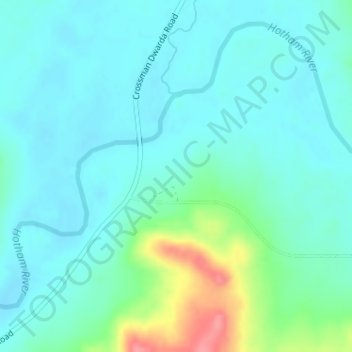
Nome: Mapa topográfico Dwarda, altitude, relevo.
Local: Dwarda, Shire Of Wandering, Western Australia, Australia (-32.77684 116.67370 -32.75684 116.69370)
Altitude média: 245 m
Altitude mínima: 228 m
Altitude máxima: 310 m
Outros mapas topográficos
Clique em um mapa para visualizar sua topografia, sua altitude e seu relevo.
Henley Brook
Henley Brook is situated on the flood plains of the Swan River, with regularly occurring seasonal floods. Two ephemeral streams from the river - Henley Brook and St. Leonard's Creek - traverse the suburb. Henley Brook is in the north-east near Brockman Street, while St Leonards Creek traverses the centre of…
Altitude média: 28 m