
Mapa topográfico Steep Point
Clique no mapa para exibir a altitude.
Sobre este mapa
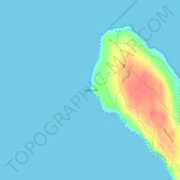
Nome: Mapa topográfico Steep Point, altitude, relevo.
Local: Steep Point, Carrarang, Western Australia, 6532, Australia (-26.15233 113.15601 -26.15223 113.15611)
Altitude média: 11 m
Altitude mínima: 0 m
Altitude máxima: 70 m
Outros mapas topográficos
Clique em um mapa para visualizar sua topografia, sua altitude e seu relevo.
Kalbarri
Kalbarri is a coastal town in the Mid West region located 592 km (368 mi) north of Perth, Western Australia. The town is located at the mouth of the Murchison River which has an elevation of 6 metres (20 ft). It is connected by public transport to Perth via Transwa coach services N1 and N2.
Altitude média: 57 m
Exmouth
In 2009, an emergency landing of the flight Qantas 72 was made at the nearby Learmonth Airport / RAAF Base Learmonth. The A330 had an incident involving the ADIRU which confused AoA (Angle of Attack) data with altitude data, making the plane think it was in a 16° pitch up when it was flying level. So the…
Altitude média: 27 m