
Faça uma doação
Mapa topográfico Conservation Area
Clique no mapa para exibir a altitude.
Faça uma doação
Sobre este mapa
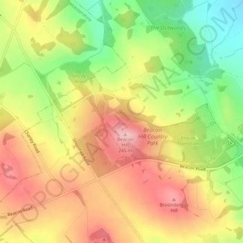
Nome: Mapa topográfico Conservation Area, altitude, relevo.
Altitude média: 168 m
Altitude mínima: 75 m
Altitude máxima: 247 m
Faça uma doação
Outros mapas topográficos
Clique em um mapa para visualizar sua topografia, sua altitude e seu relevo.
Faça uma doação
South Croxton
United Kingdom > England > Leicestershire > Charnwood > South Croxton
The highest point is the church, at 120 m above mean sea level. The lowest altitude is 85 m by the Queniborough Brook.
Altitude média: 108 m
Queniborough
United Kingdom > England > Leicestershire > Charnwood > Queniborough
Altitude média: 75 m
Barrow upon Soar
United Kingdom > England > Leicestershire > Charnwood > Barrow upon Soar
Altitude média: 62 m
Faça uma doação
Faça uma doação
Charnwood Water
United Kingdom > England > Leicestershire > Charnwood > Woodthorpe
Altitude média: 47 m
Faça uma doação
Old John
United Kingdom > England > Leicestershire > Charnwood > Newtown Linford
Altitude média: 143 m
Faça uma doação
Six Hills
United Kingdom > England > Leicestershire > Charnwood > Burton on the Wolds
Altitude média: 128 m
Faça uma doação
Faça uma doação
East Goscote
United Kingdom > England > Leicestershire > Charnwood > East Goscote
Altitude média: 61 m
Faça uma doação
Faça uma doação
Beeby
United Kingdom > England > Leicestershire > Charnwood
The physical and historical development of the hamlet has been strongly influenced by the local topography and its relative isolation. Beeby is situated within an established agricultural landscape largely in pastoral use. Until 1904 the east-west route was the only route through the hamlet, which was referred…
Altitude média: 101 m
Barrow upon Soar
United Kingdom > England > Leicestershire > Charnwood > Barrow upon Soar
Altitude média: 62 m
Faça uma doação
Faça uma doação