Faça uma doação
Mapa topográfico Swithland
Clique no mapa para exibir a altitude.
Faça uma doação
Sobre este mapa
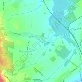
Nome: Mapa topográfico Swithland, altitude, relevo.
Local: Swithland, Charnwood, Leicestershire, England, United Kingdom (52.69883 -1.20580 52.72337 -1.16418)
Altitude média: 74 m
Altitude mínima: 55 m
Altitude máxima: 128 m
Faça uma doação
Outros mapas topográficos
Clique em um mapa para visualizar sua topografia, sua altitude e seu relevo.
Watermead Country Park
United Kingdom > England > Leicestershire > Charnwood > Birstall
Altitude média: 59 m
Faça uma doação
Bradgate Park
United Kingdom > England > Leicestershire > Charnwood > Newtown Linford
Overlying the Beacon Hill Formation, but found a little further down the hillside to the south, are the Bradgate Formation beds, the most notable of which is the Sliding Stone Slump Breccia rocks. Forming a line of crags below Old John, these are laminated mudstones, with layers of sandstone, mainly of…
Altitude média: 126 m
Faça uma doação
Lea Wood
United Kingdom > England > Leicestershire > Charnwood > Newtown Linford
Altitude média: 170 m
Faça uma doação
Old John
United Kingdom > England > Leicestershire > Charnwood > Newtown Linford
Altitude média: 143 m
Six Hills
United Kingdom > England > Leicestershire > Charnwood > Burton on the Wolds
Altitude média: 128 m
Faça uma doação
Swithland Wood
United Kingdom > England > Leicestershire > Charnwood > Swithland
Altitude média: 107 m
Beacon Hill Country Park
United Kingdom > England > Leicestershire > Charnwood > Woodhouse Eaves
Altitude média: 164 m
Faça uma doação
Top Town Plantation
United Kingdom > England > Leicestershire > Charnwood > Walton on the Wolds
Altitude média: 85 m
Faça uma doação
