
Obrigado por apoiar este site ❤️
Faça uma doação
Faça uma doação
Mapa topográfico Old John
Clique no mapa para exibir a altitude.
Obrigado por apoiar este site ❤️
Faça uma doação
Faça uma doação
Sobre este mapa
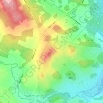
Nome: Mapa topográfico Old John, altitude, relevo.
Altitude média: 143 m
Altitude mínima: 80 m
Altitude máxima: 234 m
Obrigado por apoiar este site ❤️
Faça uma doação
Faça uma doação
Outros mapas topográficos
Clique em um mapa para visualizar sua topografia, sua altitude e seu relevo.
Bradgate Park
United Kingdom > England > Leicestershire > Charnwood > Newtown Linford
Overlying the Beacon Hill Formation, but found a little further down the hillside to the south, are the Bradgate Formation beds, the most notable of which is the Sliding Stone Slump Breccia rocks. Forming a line of crags below Old John, these are laminated mudstones, with layers of sandstone, mainly of…
Altitude média: 126 m
Lea Wood
United Kingdom > England > Leicestershire > Charnwood > Newtown Linford
Altitude média: 170 m