
Faça uma doação
Mapa topográfico Felton
Clique no mapa para exibir a altitude.
Faça uma doação
Sobre este mapa
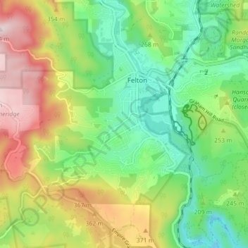
Nome: Mapa topográfico Felton, altitude, relevo.
Local: Felton, Santa Cruz County, California, United States (37.02352 -122.10617 37.05955 -122.03730)
Altitude média: 230 m
Altitude mínima: 26 m
Altitude máxima: 558 m
Faça uma doação
Outros mapas topográficos
Clique em um mapa para visualizar sua topografia, sua altitude e seu relevo.
Faça uma doação
Boulder Creek
United States > California > Santa Cruz County > Brookdale
Boulder Creek sits at the north end of the San Lorenzo Valley at the confluence of San Lorenzo River and Boulder Creek within the Santa Cruz Mountains, a Level IV ecoregion designated by the United States Environmental Protection Agency (EPA), an area surrounded by steep, redwood- and pine- covered hills…
Altitude média: 287 m
Shangri La Estates
United States > California > Santa Cruz County > Pleasure Point
Altitude média: 12 m
Faça uma doação
Scotts Valley
United States > California > Santa Cruz County
Approximately ten thousand years ago there was a lake in the lowest elevation of Scotts Valley, and Paleo Indians lived near its shores. Archeological excavations of site CA-SCR-177 in 1983 and 1987 support dates for human settlement of this area as between 9,000 and 12,000 years before present (YBP). The lake…
Altitude média: 203 m
Faça uma doação
Scotts Valley
United States > California > Santa Cruz County
Approximately ten thousand years ago there was a lake in the lowest elevation of Scotts Valley. Archeological excavations of site CA-SCR-177 (Scotts Valley Site) in 1983 and 1987 support dates for human settlement of this area as between 9,000 and 12,000 years before present (YBP). The lake drained during the…
Altitude média: 203 m
Faça uma doação
Faça uma doação
Faça uma doação
Boulder Creek
United States > California > Santa Cruz County
Boulder Creek sits at the north end of the San Lorenzo Valley at the confluence of San Lorenzo River and Boulder Creek within the Santa Cruz Mountains, a Level IV ecoregion designated by the United States Environmental Protection Agency (EPA), an area surrounded by steep, redwood- and pine- covered hills…
Altitude média: 287 m
Huckleberry Woods
United States > California > Santa Cruz County > Boulder Creek
Altitude média: 263 m
Faça uma doação
Scotts Valley
United States > California > Santa Cruz County
Approximately ten thousand years ago there was a lake in the lowest elevation of Scotts Valley. Archeological excavations of site CA-SCR-177 (Scotts Valley Site) in 1983 and 1987 support dates for human settlement of this area as between 9,000 and 12,000 years before present (YBP). The lake drained during the…
Altitude média: 203 m
Faça uma doação
Boulder Creek
United States > California > Santa Cruz County > Brookdale
Boulder Creek sits at the north end of the San Lorenzo Valley at the confluence of San Lorenzo River and Boulder Creek within the Santa Cruz Mountains, a Level IV ecoregion designated by the United States Environmental Protection Agency (EPA), an area surrounded by steep, redwood- and pine- covered hills…
Altitude média: 287 m
Faça uma doação