
Faça uma doação
Mapa topográfico Boulder Creek
Clique no mapa para exibir a altitude.
Faça uma doação
Boulder Creek
Boulder Creek sits at the north end of the San Lorenzo Valley at the confluence of San Lorenzo River and Boulder Creek within the Santa Cruz Mountains, a Level IV ecoregion designated by the United States Environmental Protection Agency (EPA), an area surrounded by steep, redwood- and pine- covered hills formed by the river, creek, and their tributaries. The river flows through Boulder Creek on the east and south through Brookdale, Ben Lomond, and Felton, and continues south to the City of Santa Cruz where it enters Monterey Bay. Directly across from Boulder Creek's confluence with the San Lorenzo River, Bear Creek flows into the river and creates a topographical feature known as the Turkey Foot. The Turkey Foot creates a floodplain, particularly on the western side of the river where the mountainside is less steep.
Faça uma doação
Sobre este mapa
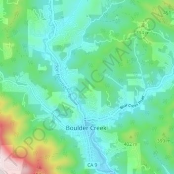
Nome: Mapa topográfico Boulder Creek, altitude, relevo.
Altitude média: 287 m
Altitude mínima: 136 m
Altitude máxima: 799 m
Faça uma doação