
Faça uma doação
Mapa topográfico Scotts Valley
Clique no mapa para exibir a altitude.
Faça uma doação
Scotts Valley
Approximately ten thousand years ago there was a lake in the lowest elevation of Scotts Valley, and Paleo Indians lived near its shores. Archeological excavations of site CA-SCR-177 in 1983 and 1987 support dates for human settlement of this area as between 9,000 and 12,000 years before present (YBP). The lake later receded to form a peat bog. Later, around 2000 BC, Ohlone people occupied areas along the remaining creeks, spring and seep areas, along with permanent and seasonal drainages, and on flat ridges and terraces. Therefore, areas along watercourses are considered likely locations for prehistoric cultural resources. Several watercourses, including portions of Carbonera Creek, Bean Creek, and MacKenzie Creek, are within the city. Permanent villages were usually placed on elevations above seasonal flood levels. Surrounding areas were used for hunting and seed, acorn, and grass gathering.
Faça uma doação
Sobre este mapa
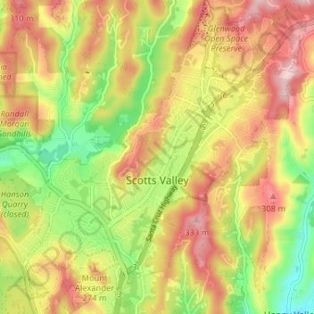
Nome: Mapa topográfico Scotts Valley, altitude, relevo.
Altitude média: 203 m
Altitude mínima: 63 m
Altitude máxima: 332 m
Faça uma doação
Outros mapas topográficos
Clique em um mapa para visualizar sua topografia, sua altitude e seu relevo.
Faça uma doação
Live Oak
United States > California > Santa Cruz County > Live Oak
Live Oak is a census-designated place (CDP) in Santa Cruz County, California between the cities of Santa Cruz and Capitola and north of the former Union Pacific railroad. Live Oak sits at an elevation of 102 feet (31 m). The population was 17,038 at the 2020 census. The population of the greater Live Oak area,…
Altitude média: 47 m
Shangri La Estates
United States > California > Santa Cruz County > Pleasure Point
Altitude média: 12 m
Faça uma doação
Faça uma doação
Faça uma doação
Faça uma doação
Faça uma doação
Huckleberry Woods
United States > California > Santa Cruz County > Boulder Creek
Altitude média: 263 m
Faça uma doação
Faça uma doação