
Faça uma doação
Mapa topográfico Pacheco Pass
Clique no mapa para exibir a altitude.
Faça uma doação
Pacheco Pass
Pacheco Pass, elevation 1,368 ft (417 m), is a low mountain pass located in the Diablo Range in southeastern Santa Clara County, California. It is the main route through the hills separating the Santa Clara Valley and the Central Valley.
Faça uma doação
Sobre este mapa
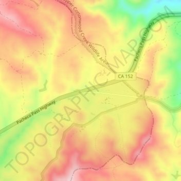
Nome: Mapa topográfico Pacheco Pass, altitude, relevo.
Altitude média: 425 m
Altitude mínima: 272 m
Altitude máxima: 525 m
Faça uma doação
Outros mapas topográficos
Clique em um mapa para visualizar sua topografia, sua altitude e seu relevo.
Faça uma doação
Mount Madonna County Park
United States > California > Santa Clara County > Watsonville
Altitude média: 330 m
San Martin
United States > California > Santa Clara County > San Martin
Due to the moderating influence of the Pacific Ocean, San Martin enjoys a warm, Mediterranean climate. Temperatures range from an average midsummer maximum of 90.2°F (32.3°C) to an average midwinter low of 33.6 °F (0.9 °C). Average annual rainfall is 480 mm (18.9 in), and the summer months are typically…
Altitude média: 100 m
Faça uma doação
Almaden Quicksilver County Park
United States > California > Santa Clara County > San Jose
Almaden Quicksilver County Park is a 4,163 acres (17 km²) park that includes the grounds of former mercury ("quicksilver") mines adjacent to south San Jose, California, USA. The park's elevation varies greatly: the most used entrances (on the east side of the park) are less than 600 feet (183 m) above sea…
Altitude média: 267 m
Faça uma doação
Sierra Vista Open Space Preserve
United States > California > Santa Clara County > San Jose
Altitude média: 484 m
Fremont Older Open Space Preserve
United States > California > Santa Clara County
Altitude média: 212 m
Faça uma doação
Santa Teresa County Park
United States > California > Santa Clara County > San Jose
Altitude média: 150 m
Los Gatos Creek County Park
United States > California > Santa Clara County > Campbell
Altitude média: 75 m
Faça uma doação