
Faça uma doação
Mapa topográfico Uvas Reservoir
Clique no mapa para exibir a altitude.
Faça uma doação
Sobre este mapa
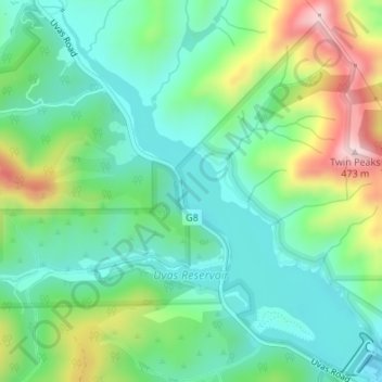
Nome: Mapa topográfico Uvas Reservoir, altitude, relevo.
Altitude média: 224 m
Altitude mínima: 121 m
Altitude máxima: 455 m
Faça uma doação
Outros mapas topográficos
Clique em um mapa para visualizar sua topografia, sua altitude e seu relevo.
Sierra Vista Open Space Preserve
United States > California > Santa Clara County > San Jose
Altitude média: 484 m
Morgan Hill
United States > California > Santa Clara County > Morgan Hill
Morgan Hill is approximately 39 km (24 mi) south of downtown San Jose, 21 km (13 mi) north of Gilroy, and 24 km (15 mi) inland from the Pacific coast. Lying in a roughly 6 km-wide (4-mi-wide) southern extension of the Santa Clara Valley, it is bounded by the Santa Cruz Mountains to the west and the Diablo…
Altitude média: 145 m
Faça uma doação
Katzman Automated Imaging Telescope
United States > California > Santa Clara County
Altitude média: 1.039 m
Faça uma doação
Pacheco Pass
United States > California > Santa Clara County
Pacheco Pass, elevation 1,368 ft (417 m), is a low mountain pass located in the Diablo Range in southeastern Santa Clara County, California. It is the main route through the hills separating the Santa Clara Valley and the Central Valley.
Altitude média: 425 m
Faça uma doação
Los Altos
United States > California > Santa Clara County > Los Altos > Los Altos
Altitude média: 82 m
Gilroy
United States > California > Santa Clara County > Gilroy
Gilroy is approximately 16 miles (26 km) south of San Jose, California (Bailey Avenue (37.206770, -121.729150) to Monterey/Day Road (37.038210, -121.584480)) on U.S. Route 101 and 19 miles (31 km) inland from the Pacific Coast. Despite its apparent close proximity to San Jose, it is important to note that…
Altitude média: 218 m
Faça uma doação
Faça uma doação
Chemeketa Park
United States > California > Santa Clara County > Redwood Estates
Altitude média: 413 m
Los Gatos Creek County Park
United States > California > Santa Clara County > Campbell
Altitude média: 75 m
Faça uma doação
Lexington Hills
United States > California > Santa Clara County > Redwood Estates > Lexington Hills
Altitude média: 406 m
Faça uma doação
Aldercroft Heights
United States > California > Santa Clara County > Aldercroft Heights
Altitude média: 427 m
Vasona Junction
United States > California > Santa Clara County > Los Gatos > Vasona Junction
Altitude média: 89 m
Faça uma doação