
Obrigado por apoiar este site ❤️
Faça uma doação
Faça uma doação
Mapa topográfico Almaden Quicksilver County Park
Clique no mapa para exibir a altitude.
Obrigado por apoiar este site ❤️
Faça uma doação
Faça uma doação
Almaden Quicksilver County Park
Almaden Quicksilver County Park is a 4,163 acres (17 km²) park that includes the grounds of former mercury ("quicksilver") mines adjacent to south San Jose, California, USA. The park's elevation varies greatly: the most used entrances (on the east side of the park) are less than 600 feet (183 m) above sea level, while the highest point in the park is over 1,700 feet (518 m) above sea level.
Obrigado por apoiar este site ❤️
Faça uma doação
Faça uma doação
Sobre este mapa
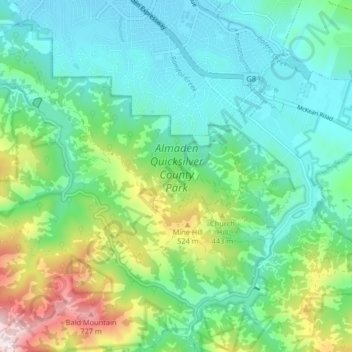
Nome: Mapa topográfico Almaden Quicksilver County Park, altitude, relevo.
Altitude média: 267 m
Altitude mínima: 77 m
Altitude máxima: 809 m
Obrigado por apoiar este site ❤️
Faça uma doação
Faça uma doação
Outros mapas topográficos
Clique em um mapa para visualizar sua topografia, sua altitude e seu relevo.
Obrigado por apoiar este site ❤️
Faça uma doação
Faça uma doação
Sierra Vista Open Space Preserve
United States > California > Santa Clara County > San Jose
Altitude média: 484 m
Obrigado por apoiar este site ❤️
Faça uma doação
Faça uma doação