
Faça uma doação
Mapa topográfico Redwoods
Clique no mapa para exibir a altitude.
Faça uma doação
Sobre este mapa
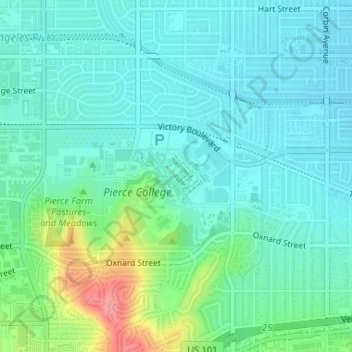
Nome: Mapa topográfico Redwoods, altitude, relevo.
Altitude média: 249 m
Altitude mínima: 229 m
Altitude máxima: 314 m
Faça uma doação
Outros mapas topográficos
Clique em um mapa para visualizar sua topografia, sua altitude e seu relevo.
Faça uma doação
Los Angeles City Council District 6
United States > California > Los Angeles County > Los Angeles
Altitude média: 252 m
Los Angeles City Council District 7
United States > California > Los Angeles County > Los Angeles
Altitude média: 512 m
West Hills Neighborhood Council District
United States > California > Los Angeles County > Los Angeles
Altitude média: 319 m
Los Angeles City Council District 5
United States > California > Los Angeles County > Los Angeles
Altitude média: 131 m
Faça uma doação
Santa Ynez Reservoir
United States > California > Los Angeles County > Los Angeles
Altitude média: 307 m
Pacific Palisades
United States > California > Los Angeles County > Los Angeles
Pacific Palisades was formally founded in 1921 by a Methodist organization, and in the years that followed became a refuge for Jewish artists and intellectuals fleeing the Holocaust. The Palisades would later be sought after by celebrities and other high-profile individuals seeking privacy. It is known for its…
Altitude média: 196 m
Faça uma doação
Topanga State Park
United States > California > Los Angeles County > Los Angeles
Altitude média: 333 m
Runyon Canyon Park
United States > California > Los Angeles County > Los Angeles
Altitude média: 235 m
Faça uma doação
Augustus F. Hawkins Natural Park
United States > California > Los Angeles County > Los Angeles
Altitude média: 55 m
Genesee Avenue Park
United States > California > Los Angeles County > Los Angeles
Altitude média: 33 m
Faça uma doação