
Mapa topográfico Hurn
Clique no mapa para exibir a altitude.
Sobre este mapa
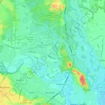
Nome: Mapa topográfico Hurn, altitude, relevo.
Altitude média: 12 m
Altitude mínima: -1 m
Altitude máxima: 54 m
Outros mapas topográficos
Clique em um mapa para visualizar sua topografia, sua altitude e seu relevo.
East Parley Common
United Kingdom > England > Bournemouth, Christchurch and Poole > Hurn
Altitude média: 13 m
Hengistbury Head
United Kingdom > England > Bournemouth, Christchurch and Poole > Bournemouth
In 1910 the first international aviation meeting ever held in Britain took place on a specially laid out aerodrome consisting of a mile of grassland between the "Double Dykes" and the nearby village of Tuckton. About twenty pioneer aviators from around the world participated in various competitions including…
Altitude média: 0 m
Throop
United Kingdom > England > Bournemouth, Christchurch and Poole > Bournemouth
Altitude média: 13 m
Kinson
United Kingdom > England > Bournemouth, Christchurch and Poole > Bournemouth
Altitude média: 26 m
Upton Heath Nature Reserve
United Kingdom > England > Bournemouth, Christchurch and Poole > Poole
Altitude média: 40 m
Bear Cross
United Kingdom > England > Bournemouth, Christchurch and Poole > Bournemouth
Altitude média: 30 m
St Catherine's Hill
United Kingdom > England > Bournemouth, Christchurch and Poole > Christchurch
Altitude média: 10 m
Redhill Park
United Kingdom > England > Bournemouth, Christchurch and Poole > Bournemouth > Talbot Village
Altitude média: 33 m
Hamworthy Park
United Kingdom > England > Bournemouth, Christchurch and Poole > Poole
Altitude média: 2 m
Kings Park
United Kingdom > England > Bournemouth, Christchurch and Poole > Bournemouth
Altitude média: 31 m
Island in the Stour
United Kingdom > England > Bournemouth, Christchurch and Poole > Poole > Merley
Altitude média: 28 m
Holdenhurst
United Kingdom > England > Bournemouth, Christchurch and Poole > Bournemouth
Altitude média: 12 m
Kinson
United Kingdom > England > Bournemouth, Christchurch and Poole > Bournemouth
Altitude média: 26 m