
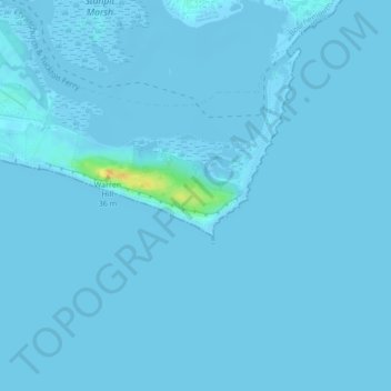
Mapa topográfico Hengistbury Head
Mapa interativo
Clique no mapa para exibir a altitude.
Sobre este mapa
Nome: Mapa topográfico Hengistbury Head, altitude, relevo.
Altitude média: 0 m
Altitude mínima: -4 m
Altitude máxima: 27 m
In 1910 the first international aviation meeting ever held in Britain took place on a specially laid out aerodrome consisting of a mile of grassland between the "Double Dykes" and the nearby village of Tuckton. About twenty pioneer aviators from around the world participated in various competitions including spot landing, altitude tests and speed trials (both for the fastest and slowest circuit).
Outros mapas topográficos
Clique em um mapa para visualizar sua topografia, sua altitude e seu relevo.
Poole
United Kingdom > England > Bournemouth, Christchurch and Poole > Merley
Poole, Merley, Bournemouth, Christchurch and Poole, England, United Kingdom
Altitude média: 23 m
Bournemouth
United Kingdom > England > Bournemouth, Christchurch and Poole > Wick
Bournemouth, Wick, Bournemouth, Christchurch and Poole, England, United Kingdom
Altitude média: 17 m
Christchurch
United Kingdom > England > Bournemouth, Christchurch and Poole > Hurn
Christchurch, Hurn, Bournemouth, Christchurch and Poole, England, United Kingdom
Altitude média: 18 m
East Parley Common
United Kingdom > England > Bournemouth, Christchurch and Poole > Hurn
East Parley Common, Hurn, Bournemouth, Christchurch and Poole, England, United Kingdom
Altitude média: 13 m
Bournemouth
United Kingdom > England > Bournemouth, Christchurch and Poole
Bournemouth, Bournemouth, Christchurch and Poole, England, BH2 6EG, United Kingdom
Altitude média: 21 m
Poole
United Kingdom > England > Bournemouth, Christchurch and Poole
Poole, Bournemouth, Christchurch and Poole, England, BH15 1SU, United Kingdom
Altitude média: 16 m
Merley
United Kingdom > England > Bournemouth, Christchurch and Poole
Merley, Bournemouth, Christchurch and Poole, England, BH21 3AQ, United Kingdom
Altitude média: 34 m
Holes Bay
United Kingdom > England > Bournemouth, Christchurch and Poole > Poole
Holes Bay, Sterte, Poole, Bournemouth, Christchurch and Poole, South West England, England, BH15 2BD, United Kingdom
Altitude média: 4 m
Upton Heath Nature Reserve
United Kingdom > England > Bournemouth, Christchurch and Poole > Poole
Upton Heath Nature Reserve, Lytchett Minster and Upton, Poole, Bournemouth, Christchurch and Poole, South West England, England, BH17 7BQ, United Kingdom
Altitude média: 40 m
Kinson
United Kingdom > England > Bournemouth, Christchurch and Poole
Kinson, Bournemouth, Christchurch and Poole, England, BH10 7AY, United Kingdom
Altitude média: 26 m
Christchurch
United Kingdom > England > Bournemouth, Christchurch and Poole > Christchurch
Christchurch, Bournemouth, Christchurch and Poole, South West England, England, United Kingdom
Altitude média: 8 m
Hurn
United Kingdom > England > Bournemouth, Christchurch and Poole
Hurn, Bournemouth, Christchurch and Poole, England, United Kingdom
Altitude média: 12 m
Talbot Village
United Kingdom > England > Bournemouth, Christchurch and Poole
Talbot Village, Bournemouth, Christchurch and Poole, England, BH10 4JA, United Kingdom
Altitude média: 40 m
Wick
United Kingdom > England > Bournemouth, Christchurch and Poole
Wick, Bournemouth, Christchurch and Poole, England, BH6 4LP, United Kingdom
Altitude média: 4 m
Highcliffe-on-Sea
United Kingdom > England > Bournemouth, Christchurch and Poole
Highcliffe-on-Sea, Bournemouth, Christchurch and Poole, England, BH23 5GD, United Kingdom
Altitude média: 19 m