
Mapa topográfico Poole
Clique no mapa para exibir a altitude.
Sobre este mapa
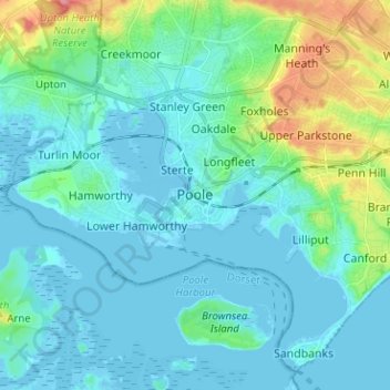
Nome: Mapa topográfico Poole, altitude, relevo.
Altitude média: 16 m
Altitude mínima: -7 m
Altitude máxima: 87 m
Outros mapas topográficos
Clique em um mapa para visualizar sua topografia, sua altitude e seu relevo.
Christchurch
United Kingdom > England > Bournemouth, Christchurch and Poole > Hurn
Altitude média: 18 m
East Parley Common
United Kingdom > England > Bournemouth, Christchurch and Poole > Hurn
Altitude média: 13 m
Upton Heath Nature Reserve
United Kingdom > England > Bournemouth, Christchurch and Poole > Poole
Altitude média: 40 m
Redhill Park
United Kingdom > England > Bournemouth, Christchurch and Poole > Bournemouth > Talbot Village
Altitude média: 33 m
Hamworthy Park
United Kingdom > England > Bournemouth, Christchurch and Poole > Poole
Altitude média: 2 m
Kings Park
United Kingdom > England > Bournemouth, Christchurch and Poole > Bournemouth
Altitude média: 31 m
Christchurch
United Kingdom > England > Bournemouth, Christchurch and Poole > Christchurch
Altitude média: 8 m
Christchurch
United Kingdom > England > Bournemouth, Christchurch and Poole > Christchurch
Altitude média: 18 m
Christchurch
United Kingdom > England > Bournemouth, Christchurch and Poole > Hurn
Altitude média: 18 m
Island in the Stour
United Kingdom > England > Bournemouth, Christchurch and Poole > Poole > Merley
Altitude média: 28 m
Christchurch
United Kingdom > England > Bournemouth, Christchurch and Poole > Hurn
Altitude média: 18 m