
Faça uma doação
Mapa topográfico Bainbridge
Clique no mapa para exibir a altitude.
Faça uma doação
Sobre este mapa
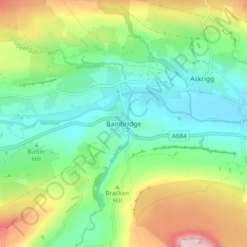
Nome: Mapa topográfico Bainbridge, altitude, relevo.
Local: Bainbridge, North Yorkshire, England, DL8 3EF, United Kingdom (54.28759 -2.12298 54.32759 -2.08298)
Altitude média: 290 m
Altitude mínima: 196 m
Altitude máxima: 477 m
Faça uma doação
Outros mapas topográficos
Clique em um mapa para visualizar sua topografia, sua altitude e seu relevo.
Faça uma doação
Malton
United Kingdom > England > North Yorkshire
As with the rest of the British Isles and Yorkshire, Malton possesses a maritime climate with cool summers and mild winters. The nearest Met Office weather station for which records are available is High Mowthorpe, about 6 miles (10 km) east of the town centre. Due to its lower elevation, the town centre is…
Altitude média: 28 m
Faça uma doação
Faça uma doação
Faça uma doação
Faça uma doação
Howe
United Kingdom > England > North Yorkshire > Hambleton > Skipton on Swale > Howe
Altitude média: 28 m
Faça uma doação
Craven
United Kingdom > England > North Yorkshire
Vegetation in the Pennines is adapted to subarctic climates, but altitude and acidity are also factors. For example, on Sutton Moor the millstone grit's topsoil below 275 m (902 ft) has a soil ph that is almost neutral, ph 6 to 7, and so grows good grazing. However, above 275 m (902 ft) it is acidic, ph 2 to…
Altitude média: 294 m
Exelby, Leeming and Londonderry
United Kingdom > England > North Yorkshire > Hambleton
Altitude média: 35 m
Great Ayton
United Kingdom > England > North Yorkshire > Hambleton > Great Ayton
Altitude média: 119 m
Faça uma doação
Milby Cut
United Kingdom > England > North Yorkshire > Harrogate > Aldborough > Milby
Altitude média: 20 m
Faça uma doação