
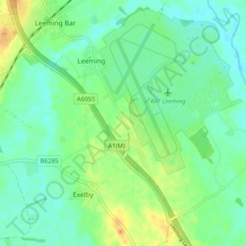
Mapa topográfico Exelby, Leeming and Londonderry
Mapa interativo
Clique no mapa para exibir a altitude.
Sobre este mapa
Nome: Mapa topográfico Exelby, Leeming and Londonderry, altitude, relevo.
Altitude média: 35 m
Altitude mínima: 24 m
Altitude máxima: 54 m
Outros mapas topográficos
Clique em um mapa para visualizar sua topografia, sua altitude e seu relevo.
Northallerton
United Kingdom > England > North Yorkshire > Hambleton
Northallerton, Hambleton, North Yorkshire, England, United Kingdom
Altitude média: 56 m
Thornton-on-the-Hill
United Kingdom > England > North Yorkshire > Hambleton
Thornton-on-the-Hill, Hambleton, North Yorkshire, England, United Kingdom
Altitude média: 80 m
Stokesley
United Kingdom > England > North Yorkshire > Hambleton
Stokesley, Hambleton, North Yorkshire, England, United Kingdom
Altitude média: 74 m
Great Ayton
United Kingdom > England > North Yorkshire > Hambleton > Great Ayton
Great Ayton, Hambleton, North Yorkshire, Yorkshire and the Humber, England, United Kingdom
Altitude média: 119 m
Howe
United Kingdom > England > North Yorkshire > Hambleton > Skipton on Swale > Howe
Howe, Skipton on Swale, Hambleton, North Yorkshire, Yorkshire and the Humber, England, YO7 4HU, United Kingdom
Altitude média: 28 m