
Faça uma doação
Mapa topográfico Malton
Clique no mapa para exibir a altitude.
Faça uma doação
Malton
As with the rest of the British Isles and Yorkshire, Malton possesses a maritime climate with cool summers and mild winters. The nearest Met Office weather station for which records are available is High Mowthorpe, about 6 miles (10 km) east of the town centre. Due to its lower elevation, the town centre is likely to be marginally warmer than High Mowthorpe throughout the year.
Faça uma doação
Sobre este mapa
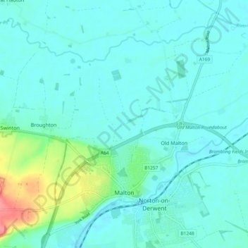
Nome: Mapa topográfico Malton, altitude, relevo.
Local: Malton, North Yorkshire, England, United Kingdom (54.12565 -0.82388 54.17406 -0.73200)
Altitude média: 28 m
Altitude mínima: 15 m
Altitude máxima: 91 m
Faça uma doação
Outros mapas topográficos
Clique em um mapa para visualizar sua topografia, sua altitude e seu relevo.
Faça uma doação
Faça uma doação
Faça uma doação
Faça uma doação
Faça uma doação
Faça uma doação
Milby Cut
United Kingdom > England > North Yorkshire > Harrogate > Aldborough > Milby
Altitude média: 20 m