
Mapa topográfico Frimley
Clique no mapa para exibir a altitude.
Sobre este mapa
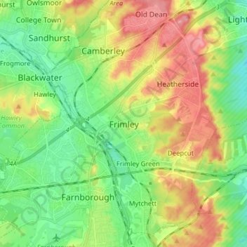
Nome: Mapa topográfico Frimley, altitude, relevo.
Altitude média: 82 m
Altitude mínima: 55 m
Altitude máxima: 132 m
Outros mapas topográficos
Clique em um mapa para visualizar sua topografia, sua altitude e seu relevo.
Chobham Common
United Kingdom > England > Surrey > Surrey Heath > Chobham > Brick Hill
Altitude média: 49 m
Frimley Lodge Park
United Kingdom > England > Surrey > Surrey Heath > Frimley Green
Altitude média: 80 m
Chobham
United Kingdom > England > Surrey > Surrey Heath
The rolling basin below reaches lowest elevations of between 30 metres (98 ft) in the centre of the west and 20 metres (66 ft) where the rivers join in the centre of the east. The rivers at the western point are less than 100 metres (330 ft) apart; to the east end of the parish where the parish adjoins the…
Altitude média: 43 m