
Mapa topográfico Chobham
Clique no mapa para exibir a altitude.
Chobham
The rolling basin below reaches lowest elevations of between 30 metres (98 ft) in the centre of the west and 20 metres (66 ft) where the rivers join in the centre of the east. The rivers at the western point are less than 100 metres (330 ft) apart; to the east end of the parish where the parish adjoins the landscape of the McLaren Technology Centre the rivers are finally merged along that boundary.
Sobre este mapa
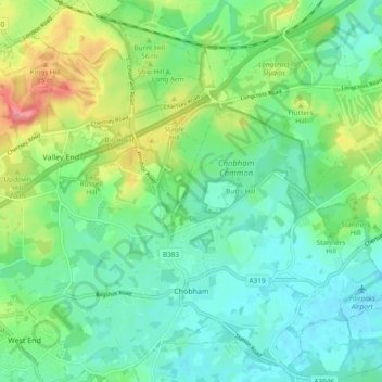
Nome: Mapa topográfico Chobham, altitude, relevo.
Local: Chobham, Surrey Heath, Surrey, England, United Kingdom (51.33363 -0.64098 51.39246 -0.54851)
Altitude média: 43 m
Altitude mínima: 19 m
Altitude máxima: 99 m
Outros mapas topográficos
Clique em um mapa para visualizar sua topografia, sua altitude e seu relevo.
Camberley
United Kingdom > England > Surrey > Surrey Heath
The Staff College, to the north of Camberley town centre, is part of the Joint Services Command and Staff College, which provides training and education for established officers in the British Armed Forces and civil servants in the Ministry of Defence. The institution has its origins in the Royal Military…
Altitude média: 88 m
Frimley Lodge Park
United Kingdom > England > Surrey > Surrey Heath > Frimley Green
Altitude média: 80 m
Camberley
United Kingdom > England > Surrey > Surrey Heath
The Staff College, to the north of Camberley town centre, is part of the Joint Services Command and Staff College, which provides training and education for established officers in the British Armed Forces and civil servants in the Ministry of Defence. The institution has its origins in the Royal Military…
Altitude média: 88 m