
Mapa topográfico Frimley
Clique no mapa para exibir a altitude.
Sobre este mapa
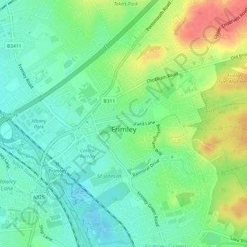
Nome: Mapa topográfico Frimley, altitude, relevo.
Local: Frimley, Surrey Heath, Surrey, England, United Kingdom (51.31000 -0.75831 51.32220 -0.72095)
Altitude média: 72 m
Altitude mínima: 56 m
Altitude máxima: 115 m
Outros mapas topográficos
Clique em um mapa para visualizar sua topografia, sua altitude e seu relevo.
Camberley
United Kingdom > England > Surrey > Surrey Heath
The Staff College, to the north of Camberley town centre, is part of the Joint Services Command and Staff College, which provides training and education for established officers in the British Armed Forces and civil servants in the Ministry of Defence. The institution has its origins in the Royal Military…
Altitude média: 88 m
Frimley Lodge Park
United Kingdom > England > Surrey > Surrey Heath > Frimley Green
Altitude média: 80 m
Camberley
United Kingdom > England > Surrey > Surrey Heath
The Staff College, to the north of Camberley town centre, is part of the Joint Services Command and Staff College, which provides training and education for established officers in the British Armed Forces and civil servants in the Ministry of Defence. The institution has its origins in the Royal Military…
Altitude média: 88 m