
Faça uma doação
Mapa topográfico Buck Creek
Clique no mapa para exibir a altitude.
Faça uma doação
Sobre este mapa
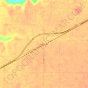
Nome: Mapa topográfico Buck Creek, altitude, relevo.
Local: Buck Creek, Tippecanoe County, Indiana, 47924, United States (40.46781 -86.78140 40.50781 -86.74140)
Altitude média: 202 m
Altitude mínima: 164 m
Altitude máxima: 209 m
Faça uma doação
Outros mapas topográficos
Clique em um mapa para visualizar sua topografia, sua altitude e seu relevo.
West Lafayette
United States > Indiana > Tippecanoe County
West Lafayette, located in Tippecanoe County, Indiana, presents a varied topography, particularly shaped by its proximity to the Wabash River. The city spans an elevation range from approximately 500 feet near the river to over 720 feet in its northern sections, offering a noticeable incline toward higher…
Altitude média: 192 m
Lafayette
United States > Indiana > Tippecanoe County
Lafayette is located at 40°24′38″N 86°52′29″W / 40.410585°N 86.874681°W / 40.410585; -86.874681 (40.410585, −86.874681) and is located in Fairfield and Wea Townships. Elevation at the court house is 550 feet (168 m), but city elevations range from a little over 500 feet (150 m) at the…
Altitude média: 192 m
West Lafayette
United States > Indiana > Tippecanoe County
West Lafayette lies in central Tippecanoe County and overlooks the Wabash River, which borders the city on the east and south. Most of the city lies in eastern Wabash Township, though a small portion on the northeast side extends into Tippecanoe Township. Elevations range from slightly over 500 feet (150 m)…
Altitude média: 192 m
Faça uma doação