
Faça uma doação
Mapa topográfico Lafayette
Clique no mapa para exibir a altitude.
Faça uma doação
Lafayette
Lafayette is located at 40°24′38″N 86°52′29″W / 40.410585°N 86.874681°W / 40.410585; -86.874681 (40.410585, −86.874681) and is located in Fairfield and Wea Townships. Elevation at the court house is 550 feet (168 m), but city elevations range from a little over 500 feet (150 m) at the Wabash River to approximately 700 feet (210 m) in the areas of Murdock Park and Columbian Park.
Faça uma doação
Sobre este mapa
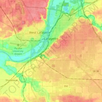
Nome: Mapa topográfico Lafayette, altitude, relevo.
Local: Lafayette, Tippecanoe County, Indiana, United States (40.35564 -86.92609 40.45548 -86.77976)
Altitude média: 192 m
Altitude mínima: 151 m
Altitude máxima: 225 m
Faça uma doação
Outros mapas topográficos
Clique em um mapa para visualizar sua topografia, sua altitude e seu relevo.
Happy Hollow Heights
United States > Indiana > Tippecanoe County > West Lafayette > Happy Hollow Heights
Altitude média: 189 m