
Faça uma doação
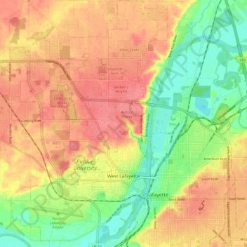
Mapa topográfico West Lafayette
Clique no mapa para exibir a altitude.
Faça uma doação
West Lafayette
West Lafayette, located in Tippecanoe County, Indiana, presents a varied topography, particularly shaped by its proximity to the Wabash River. The city spans an elevation range from approximately 500 feet near the river to over 720 feet in its northern sections, offering a noticeable incline toward higher ground. The river itself borders the city to the east and south, providing a valley-like feature that influences the surrounding landscape. Northern areas, near U.S. Route 52, are situated on more elevated terrain. This diverse elevation contributes to a mix of flat river plains and rolling hills, offering both scenic views and practical land use for residential and university spaces.
Faça uma doação
Sobre este mapa
Nome: Mapa topográfico West Lafayette, altitude, relevo.
Local: West Lafayette, Tippecanoe County, Indiana, United States (40.40002 -86.96244 40.48954 -86.88698)
Altitude média: 192 m
Altitude mínima: 150 m
Altitude máxima: 225 m
Faça uma doação
Outros mapas topográficos
Clique em um mapa para visualizar sua topografia, sua altitude e seu relevo.
Happy Hollow Heights
United States > Indiana > Tippecanoe County > West Lafayette > Happy Hollow Heights
Altitude média: 189 m