
Obrigado por apoiar este site ❤️
Faça uma doação
Faça uma doação
Mapa topográfico West End
Clique no mapa para exibir a altitude.
Obrigado por apoiar este site ❤️
Faça uma doação
Faça uma doação
Sobre este mapa
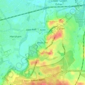
Nome: Mapa topográfico West End, altitude, relevo.
Local: West End, Elmbridge, Surrey, England, KT10 8LY, United Kingdom (51.34275 -0.39929 51.38275 -0.35929)
Altitude média: 24 m
Altitude mínima: 8 m
Altitude máxima: 54 m
Obrigado por apoiar este site ❤️
Faça uma doação
Faça uma doação
Outros mapas topográficos
Clique em um mapa para visualizar sua topografia, sua altitude e seu relevo.
Cobham
United Kingdom > England > Surrey > Elmbridge
The River Mole runs through Cobham, with a visitor area and well-surfaced path by the mill in the High Street, dividing the low-rise urban village/town centre from the remaining agricultural parts of Cobham in the west and south. This can flood small, old parts of the village centre in extreme rainfall.…
Altitude média: 28 m