
Faça uma doação
Mapa topográfico La Candelaria
Clique no mapa para exibir a altitude.
Faça uma doação
Sobre este mapa
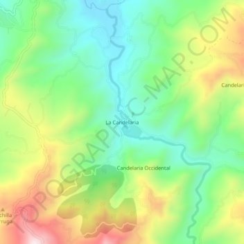
Nome: Mapa topográfico La Candelaria, altitude, relevo.
Local: La Candelaria, Ricaurte, Boyacá, Colombia (5.50075 -73.62567 5.54075 -73.58567)
Altitude média: 2.354 m
Altitude mínima: 2.142 m
Altitude máxima: 2.698 m
Faça uma doação
Outros mapas topográficos
Clique em um mapa para visualizar sua topografia, sua altitude e seu relevo.
Gachantivá
Gachantivá is a town and municipality in the Ricaurte Province, part of the Colombian department of Boyacá. Gachantivá is located at altitudes ranging from 2,000 metres (6,600 ft) to 3,300 metres (10,800 ft) on the Altiplano Cundiboyacense and borders Villa de Leyva in the south, Santa Sofía in the west,…
Altitude média: 2.365 m
Villa de Leyva
Located away from major trade routes in a high altitude valley of semi-desert terrain, and with no mineral deposits nearby to exploit, the town has undergone little development in the last 400 years. As a consequence, it is one of the few towns in Colombia to have preserved completely its original colonial…
Altitude média: 2.416 m
Faça uma doação
Garagoa
Garagoa (Spanish pronunciation: [ɡaɾaˈɣoa]) is a town and municipality in Colombia, located in the Boyacá Department. It covers an area of 191.75 km2 and the urban centre is located at an altitude of 1,650 metres (5,410 ft) above sea level. Parts of the municipality reach altitudes of 3,050 metres (10,010…
Altitude média: 1.988 m
Faça uma doação
Villa de Leyva
Located away from major trade routes in a high altitude valley of semi-desert terrain, and with no mineral deposits nearby to exploit, the town has undergone little development in the last 400 years. As a consequence, it is one of the few towns in Colombia to have preserved much of its original colonial style…
Altitude média: 2.416 m
Faça uma doação
Parque Natural Regional Páramo de Rabanal
Colombia > Boyacá > Guachetá > Samacá
Altitude média: 3.071 m
Faça uma doação
Rondón
Rondón is a town and municipality in the Márquez Province, part of Boyacá Department, Colombia. The urban centre of Rondón is situated at an altitude of 2,075 metres (6,808 ft) on the Altiplano Cundiboyacense in the Colombian Eastern Ranges of the Andes. It is 61 kilometres (38 mi) away from the…
Altitude média: 2.472 m
Duitama
Duitama (Spanish pronunciation: [dwiˈtama]) is a city and municipality in the department of Boyacá. It is the capital of the Tundama Province. Duitama is located 195 kilometres (121 mi) northeast of Bogotá, the capital city of Colombia and 50 kilometres (31 mi) northeast of Tunja, the capital Boyacá.…
Altitude média: 3.019 m
Faça uma doação
Ráquira
Ráquira, is a municipality and town in Boyacá Department, Colombia, part of the subregion of the Ricaurte Province. Ráquira is situated on the Altiplano Cundiboyacense and the urban center at an altitude of 2,150 metres (7,050 ft). It borders Tinjacá and Sutamarchán in the north, Guachetá, Cundinamarca…
Altitude média: 2.677 m
Paipa
Paipa is located 15 km west of Duitama and 48 kilometres (30 mi) to the northeast of Tunja, the capital of the department, in the Cordillera Oriental (Eastern Ranges) of the Colombian Andes. It is the main tourist center of the region, with a number of large hotels and hot springs. At an elevation of 2525 m,…
Altitude média: 2.829 m
Faça uma doação
Faça uma doação
Villa de Leyva
Located away from major trade routes in a high altitude valley of semi-desert terrain, and with no mineral deposits nearby to exploit, the town has undergone little development in the last 400 years. As a consequence, it is one of the few towns in Colombia to have preserved much of its original colonial style…
Altitude média: 2.416 m
Faça uma doação