
Faça uma doação
Mapa topográfico Ráquira
Clique no mapa para exibir a altitude.
Faça uma doação
Ráquira
Ráquira, is a municipality and town in Boyacá Department, Colombia, part of the subregion of the Ricaurte Province. Ráquira is situated on the Altiplano Cundiboyacense and the urban center at an altitude of 2,150 metres (7,050 ft). It borders Tinjacá and Sutamarchán in the north, Guachetá, Cundinamarca in the south, in the east Sáchica and Samacá and in the west San Miguel de Sema and Lake Fúquene.
Faça uma doação
Sobre este mapa
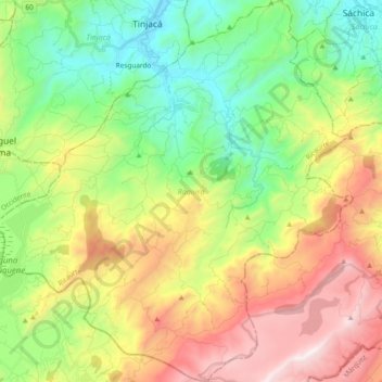
Nome: Mapa topográfico Ráquira, altitude, relevo.
Local: Ráquira, Ricaurte, Boyacá, RAP (Especial) Central, Colombia (5.40347 -73.72398 5.59054 -73.54561)
Altitude média: 2.677 m
Altitude mínima: 2.092 m
Altitude máxima: 3.586 m
Faça uma doação
Outros mapas topográficos
Clique em um mapa para visualizar sua topografia, sua altitude e seu relevo.
Tunja
Tunja has a population of 172,548 inhabitants according to the 2018 Census. 0.1% of the city is indigenous, 0.4% is black, and 99.5% is white and Mestizo. It is located in central Colombia, at an elevation ranging from approximately 2,700 metres (8,900 ft) to 2,900 metres (9,500 ft). The city centre is at an…
Altitude média: 2.824 m
Cordillera Oriental
The Cordillera Oriental montane forests ecoregion covers the eastern slopes of the cordillera and its northern end. The Magdalena Valley montane forests cover the western slopes. The Northern Andean páramo covers the highest elevations.
Altitude média: 4.825 m
Faça uma doação
Sogamoso
Sogamoso (Spanish pronunciation: [soɣaˈmoso]) is a city in the department of Boyacá of Colombia. It is the capital of the Sugamuxi Province, named after the original Sugamuxi. Sogamoso is nicknamed "City of the Sun", based on the original Muisca tradition of pilgrimage and adoring their Sun god Sué at the…
Altitude média: 2.901 m
Faça uma doação
Faça uma doação
Faça uma doação