
Faça uma doação
Mapa topográfico Duitama
Clique no mapa para exibir a altitude.
Faça uma doação
Duitama
Duitama (Spanish pronunciation: [dwiˈtama]) is a city and municipality in the department of Boyacá. It is the capital of the Tundama Province. Duitama is located 195 kilometres (121 mi) northeast of Bogotá, the capital city of Colombia and 50 kilometres (31 mi) northeast of Tunja, the capital Boyacá. Duitama has existed since pre-Columbian times, when the Muisca inhabited the hills surrounding a former lake in the valley. The original name of Duitama was "Tundama", named after cacique Tundama. The elevation of the city is about 2,590 metres (8,500 ft) above sea level and the average temperature is 16 °C. Duitama is known as "The Pearl of Boyacá".
Faça uma doação
Sobre este mapa
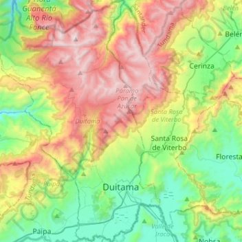
Nome: Mapa topográfico Duitama, altitude, relevo.
Local: Duitama, Tundama, Boyacá, RAP (Especial) Central, Colombia (5.77007 -73.17625 6.02490 -72.99248)
Altitude média: 3.019 m
Altitude mínima: 2.374 m
Altitude máxima: 4.036 m
Faça uma doação
Outros mapas topográficos
Clique em um mapa para visualizar sua topografia, sua altitude e seu relevo.
Tunja
Tunja has a population of 172,548 inhabitants according to the 2018 Census. 0.1% of the city is indigenous, 0.4% is black, and 99.5% is white and Mestizo. It is located in central Colombia, at an elevation ranging from approximately 2,700 metres (8,900 ft) to 2,900 metres (9,500 ft). The city centre is at an…
Altitude média: 2.824 m
Faça uma doação
Cordillera Oriental
The Cordillera Oriental montane forests ecoregion covers the eastern slopes of the cordillera and its northern end. The Magdalena Valley montane forests cover the western slopes. The Northern Andean páramo covers the highest elevations.
Altitude média: 4.825 m
Sogamoso
Sogamoso (Spanish pronunciation: [soɣaˈmoso]) is a city in the department of Boyacá of Colombia. It is the capital of the Sugamuxi Province, named after the original Sugamuxi. Sogamoso is nicknamed "City of the Sun", based on the original Muisca tradition of pilgrimage and adoring their Sun god Sué at the…
Altitude média: 2.901 m
Faça uma doação
Faça uma doação
Faça uma doação