
Mapa topográfico Naseby
Mapa interativo
Clique no mapa para exibir a altitude.
Sobre este mapa
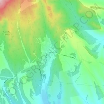
Nome: Mapa topográfico Naseby, altitude, relevo.
Local: Naseby, Central Otago District, Otago, 9396, New Zealand (-45.04563 170.12782 -45.00563 170.16782)
Altitude média: 617 m
Altitude mínima: 538 m
Altitude máxima: 786 m
Naseby is a small town, formerly a borough, in the Maniototo area of Central Otago, New Zealand. It is named after a village in Northamptonshire, England. Previous names of the township were Parker's, Hogburn and Mt Ida. The town catch phrase is "2000 feet above worry level" indicating its altitude. Naseby is 395 km (5 hours drive) from Christchurch and 143 km (1 hour 45 minutes drive) from Dunedin.
Outros mapas topográficos
Clique em um mapa para visualizar sua topografia, sua altitude e seu relevo.
Vincent Community
New Zealand > Otago > Central Otago District
Vincent Community, Central Otago District, Otago, New Zealand
Altitude média: 776 m
Becks
New Zealand > Otago > Central Otago District > Vincent Community
Becks, Vincent Community, Central Otago District, Otago, 9377, New Zealand
Altitude média: 393 m
Cromwell
New Zealand > Otago > Central Otago District > Cromwell Community > Cromwell
Cromwell, Cromwell Community, Central Otago District, Otago, 9310, New Zealand
Altitude média: 330 m
Blue Lake
New Zealand > Otago > Central Otago District > Vincent Community > Saint Bathans
Blue Lake, Saint Bathans, Vincent Community, Central Otago District, Otago, New Zealand
Altitude média: 605 m
Kakanui Peak
New Zealand > Otago > Central Otago District
Kakanui Peak, Central Otago District, Otago, New Zealand
Altitude média: 1.169 m
Central Otago
New Zealand > Otago > Central Otago District > Vincent Community
Central Otago, Vincent Community, Central Otago District, Otago, 9035, New Zealand
Altitude média: 935 m
Shingle Creek
New Zealand > Otago > Central Otago District > Teviot Valley Community
Shingle Creek, Teviot Valley Community, Central Otago District, Otago, New Zealand
Altitude média: 307 m
Ranfurly
New Zealand > Otago > Central Otago District
Ranfurly, Central Otago District, Otago, 9332, New Zealand
Altitude média: 429 m
Alexandra
New Zealand > Otago > Central Otago District > Vincent Community
Alexandra, Vincent Community, Central Otago District, Otago, 9320, New Zealand
Altitude média: 241 m
Blackstone Hill
New Zealand > Otago > Central Otago District > Vincent Community
Blackstone Hill, Vincent Community, Central Otago District, Otago, 9377, New Zealand
Altitude média: 789 m
Ophir
New Zealand > Otago > Central Otago District > Vincent Community
Ophir, Vincent Community, Central Otago District, Otago, 9376, New Zealand
Altitude média: 338 m
Roxburgh
New Zealand > Otago > Central Otago District > Teviot Valley Community
Roxburgh, Teviot Valley Community, Central Otago District, Otago, 9500, New Zealand
Altitude média: 223 m
Clyde
New Zealand > Otago > Central Otago District > Vincent Community
Clyde, Vincent Community, Central Otago District, Otago, 9330, New Zealand
Altitude média: 316 m
Cromwell Community
New Zealand > Otago > Central Otago District
Cromwell Community, Central Otago District, Otago, New Zealand
Altitude média: 876 m
Ida Valley
New Zealand > Otago > Central Otago District > Maniototo Community
Ida Valley, Maniototo Community, Central Otago District, Otago, New Zealand
Altitude média: 472 m
Muttontown
New Zealand > Otago > Central Otago District > Vincent Community > Clyde
Muttontown, Clyde, Vincent Community, Central Otago District, Otago, 9391, New Zealand
Altitude média: 207 m
Millers Flat
New Zealand > Otago > Central Otago District > Teviot Valley Community
Millers Flat, Teviot Valley Community, Central Otago District, Otago, 9572, New Zealand
Altitude média: 161 m
Wedderburn
New Zealand > Otago > Central Otago District
Wedderburn, Central Otago District, Otago, 9395, New Zealand
Altitude média: 565 m